

US
°C


A disturbance in the central Atlantic is being monitored by the National Hurricane Center for possible development.Any resulting cyclone would most likely be subtropical in nature.The disturbance follows Arthur and Bertha, two tropical storms that formed before the official start of hurricane season.Atlantic hurricane season officially starts June 1.
A broad area of low pressure in the central Atlantic is now unlikely going to be the third tropical or subtropical depression to form before hurricane season officially begins.
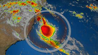
The National Hurricane Center (NHC) tagged this system Invest 92L Thursday evening, a designation that allows for specialized computer models to be run on it.
(MORE: What Is An Invest?)
The NHC gives this system low, and dwindling chance of development.
Invest 92L has been producing isolated thunderstorms and gusty winds in its northern semicircle and if this system were to develop, it would likely be subtropical in nature. This means that it will derive its energy from both warm water and from the jet stream, in this case the subtropical jet stream.
Development will likely be slow as both of those sources of energy will remain limited. Subtropical systems are also typically rather broad with an expansive wind field, which makes it more difficult for them to intensify.
The system, located 500 miles east of Bermuda and is expected to move generally northwestward over the next few days. Invest 92L will be guided northward initially by a large area of high pressure located just to the north of the tropical disturbance, then will be blocked from getting any closer to the United States or Canada by a cold front that is moving off the East Coast.
Bermuda will likely not be affected by this system directly, or by gusty winds or rainfall, but the cold front that will sweep it out to sea will bring some rain and gusty winds. Seas will be kicked up by both of these features.
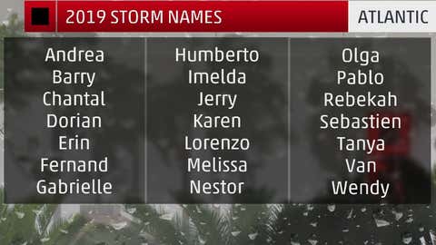
The next system to attain tropical storm intensity will gain the name 'Cristobal.'
While we had Tropical Storm Arthur two weeks ago and Tropical Storm Bertha earlier this week, it is difficult at best to say how this hurricane season will go based on just the activity we have had so far.
(DEEP DIVE: Does This Mean an Active Hurricane Season Is Guaranteed?)
Only one hurricane season has had three tropical or subtropical cyclones before June 1st: 1951. In that year, a tropical storm formed in January, followed by Hurricane Able and a tropical depression in May.
According to Colorado State University tropical scientist Phil Klotzbach, in records dating to 1851 produced two storms before June 1.
Three of these five previous seasons had an above-average number of storms and hurricanes.
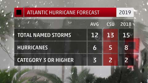
That said, looking ahead at forecast conditions rather than history, is anticipated by many forecast groups, including The Weather Company and NOAA.
The Weather Company’s primary journalistic mission is to report on breaking weather news, the environment and the importance of science to our lives. This story does not necessarily represent the position of our parent company, .


 zpostcode
 Recruit
 weather
 mreligion
 Yellowpages
 sport
sport constellation
 shopping
 name
name game
game directory
 literature
 Word
Word tour
tour furnish
 Lottery
 tftnews
 lyrics
 News
News digital
 car
car dir
dir Edu
Edu Finance


