

US
°C


Tropical Cyclone Veronica is drenching northern Western Australia.Tropical Cyclone Trevor made a second landfall in the Northern Territory early Saturday, local time.
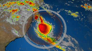
Northern Australia has been battered by two tropical cyclones, Trevor and Veronica, in a matter of days which have brought heavy rain and damaging winds.
Tropical Cyclone Veronica is currently centered just off the northwest coast of Australia to the west of Port Hedland and is a strong tropical storm.
Legendre Island, a barrier island north of Karratha, reported a wind gust to 98 mph before the station failed Sunday Morning. A wind gust to 96 mph has been recorded east of Karratha at . Port Hedland and Karratha have clocked .
Port Hedland has received more than 8 inches of rain so far, as of early Monday morning local time.
Port Hedland Mayor Camilo Blanco told that there was already flooding occurring in town even before the highest tide of the day on Saturday.
“Before this even started (on Saturday morning) the main street in town and Pier Hotel were underwater by [a foot],” he said.
Veronica will weaken due to interaction with land as it moves westward very near the northwest coast of Australia into early week.
Gusty winds and heavy rainfall are anticipated near where Veronica moves along the Pilbara coast of Western Australia. This large stretch of coastline has roughly 50,000 people.
This slow movement will result in an exposure to strong winds for an extended period of time and will increase the risk of heavy rainfall and flooding.
Widespread flooding is a serious concern due to the heavy rain that is anticipated. Some locations could see rainfall totals of more than 12 inches when all is said and done.
Tropical Cyclone Trevor made its first landfall last week as the equivalent of a hurricane in Cape York Peninsula, in northern Queensland. Heavy rain and strong winds there resulted in .
Trevor made its second landfall in the Northern Territory Saturday morning, local time, as the equivalent of a Category 3 hurricane according to the .
Wind gusts over 70 mph occurred Saturday night over inland parts of the Carpentaria District and into the Barkly District, according to the .
Trevor's remnant low and moisture will continue to bring heavy rain to parts of northern Australia through early week.
An emergency was declared in communities along the western Gulf of Carpentaria ahead of this second landfall and from remote, mostly indigenous communities on the east coast of the Northern Territory, the Associated Press reported.


 zpostcode
 Recruit
 weather
 mreligion
 Yellowpages
 sport
sport constellation
 shopping
 name
name game
game directory
 literature
 Word
Word tour
tour furnish
 Lottery
 tftnews
 lyrics
 News
News digital
 car
car dir
dir Edu
Edu Finance


