

US
°C


The forecast path for a tropical storm or hurricane shows where the center of a storm is expected to track.Impacts from a particular storm can be felt well outside of the forecast path.
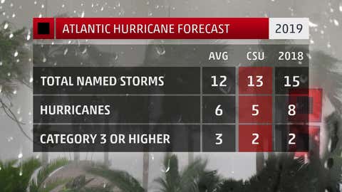
Countless times throughout hurricane season, you'll see the familiar projected path graphic for each storm roaming the Atlantic and Pacific basins. Whilethisgraphic does provide valueby showingwhere ahurricane ortropical storm is generally headed, sometimes it doesn'ttell the wholestory.
The forecast path, in a nutshell, shows the most likely track of a particular storm's center of circulation, or where its lowest atmospheric pressure is located.
The forecast path shows the most like path for a storm's center, but does not always show where impacts will occur.
This is important information since, in a hurricane, the eyewall near the centerhas the strongest winds, and is also typicallywhere the worst storm surge inundation pushes inland.
What theforecast path does not show is that significant impacts from a tropical storm or hurricane, including flooding rainfall, storm surge, strong winds and tornadoes, can occur well outside of where this so-called cone is plotted on a map.
It should also be mentioned that the size of the forecast path is drawn soabout two-thirds of the time, the center of the storm will remain in the cone. That's right – a storm's center doesn't always stay within the boundaries forecast several days in advance.
Need more proof that the forecast path doesn't reveal everything? Let's look at a couple of real examples from past years.
June 2017 was a prime example of the forecast path not telling the full story in terms of impacts.
When Tropical Storm Cindy formed in the Gulf of Mexico on June 20, the forecast path was pointed at the border between Texas and Louisiana.
Stay Safe During Storms and Power Outages with These Essential Items (SPONSORED)
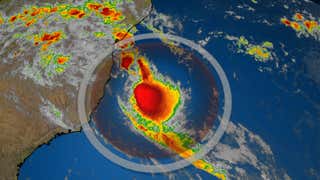
Cindy's path was completely disjointed from where the worst weather from the tropical stormwas ongoing. As the satellite image overlaid with the projected path shows below, rain and thunderstorms (orange and red shadings) extended well to the east of the path along the Gulf Coast to as far east as the Florida Panhandle.
Although Cindy's path pointed at western Louisiana and the upper Texas coast in June 2017, rain and thunderstorms extended well to the east. The yellow and red shaded area along the upper Texas and Louisiana coasts is where tropical storm watches and warnings were in effect at the time of this image, including well east of the forecast path.
That is due to the fact that Cindy was affected by strong winds in the upper atmosphere, making it a lopsided tropical storm where the worst impacts were on the right side of its circulation center.
Cindy's centereventually made landfall near the Texas/Louisiana border, but some of its heaviest rainfall, toppingeight inches, was in coastal parts of Alabama, Mississippiand the Florida Panhandle. In fact, Ocean Springs,Mississippi, recorded 18.74 inches of rain despitebeing hundreds of miles from the point of landfall.
Although Cindy wasn't a major storm surge generator, it did produce a along parts of the Mississippi, Alabama and Floridacoastline.
Another example where the cone didn't reveal the full scope ofsignificant impactswas during Hurricane Ike in September 2008.
Ike's path was directly into the Texas coast in 2008, but storm surge inundation occurred as far east as southeastern Louisiana, Mississippi, Alabama and the Florida Panhandle. (NOAA)
Ike was a large hurricane that tracked westward through theGulf of Mexico before making landfall on the upper Texas coast.
Parts of Texas's Bolivar Peninsula were wiped clean of all structures from Ike's catastrophic storm surge near the point of landfall.
Hundreds of miles east from where Ike made landfall, and far from where the forecast path is drawn on the map to the right, significant storm surge inundation also occurred.
A was observed in coastal Mississippi, Alabama and southeastern Louisiana. Even the Florida Panhandle was affected, withPensacola measuring a peak storm surge of just over 3 feet. These areas saw littlewind and rain from Ike.
Major damage , fromthe storm surge, and the road to the island was closed for two days, according to the National Weather Service. In Florida, high water closed Highway 98 in Okaloosa County for two days.
In other words, the next time a tropical storm or hurricane threatens, be sure to go look beyond the forecast path to see if you'll be affected. Chances are, impacts will likely extend beyond where the cone is pointed.


 zpostcode
 Recruit
 weather
 mreligion
 Yellowpages
 sport
sport constellation
 shopping
 name
name game
game directory
 literature
 Word
Word tour
tour furnish
 Lottery
 tftnews
 lyrics
 News
News digital
 car
car dir
dir Edu
Edu Finance


