

US
°C


Besides Josephine, we're watching a new storm move away from the East Coast.Several systems are likely to develop south and west of Mexico in the next few days.The increase in activity in the eastern Pacific is a signal that the Atlantic may follow.
As the tropics , we're entering the peak of hurricane season. The Atlantic and Eastern Pacific oceans are expected to get more active over the next few weeks.
Here are a few things we're watching in the tropics:
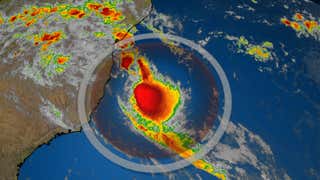
Tropical Storm Kyle formed late Friday afternoon off the coast of the mid-Atlantic with a closed center and organized thunderstorms.
This storm is accelerating northeastward and away from the United States, but it will be a concern for shipping lanes crossing the Atlantic.
Some increased surf in the Canadian Maritimes is possible this weekend.
Current Information
The Eastern Pacific is even more active as we move through mid-August.
The Hurricane Center is watching three tropical disturbances for development and one tropical depression (not pictured below).
The most concerning of these tropical disturbances is the one south of Guatemala and Mexico.
Current computer guidance suggests that this one may track northeastward, close enough to brush the southwestern coast of Mexico, and could get close enough to Cabo San Lucas late next week.
Potential Development Areas
(The potential areas of tropical development according to the latest National Hurricane Center outlook are shown by polygons, color-coded by the chance of development over the next five days. An "X" indicates the location of a current disturbance.)
The Eastern Pacific Basin could make up some lost time over the next week if some of these disturbances develop.
The basin is currently running at about 50 to 60% of the average pace through Aug. 13, with five named storms and two hurricanes. This is compared to an average of eight tropical storms and four hurricanes.
Tropical activity usually increases in the Atlantic in this window as oceanic and atmospheric conditions become most favorable for hurricane development. The peak activity occurs around Sept. 10.
About 89% of typical tropical activity in the Atlantic remains, mostly happening between now and October.
But climatology isn't the only factor that favors an active period.
A hemispheric-scale wave of increased moisture and lift called the Madden-Julian Oscillation (MJO) is moving eastward through the Pacific Ocean. When the increased moisture and lift reaches a tropical ocean basin, the chance of getting a tropical depression or storm is increased for a week or so.
(MORE: What Is the Madden-Julian Oscillation?)
In the heart of hurricane season, this MJO wave can also lead to tropical cyclone outbreaks as the wave passes. Tropical cyclone outbreaks are quick bursts of activity consisting of three or more tropical depressions or storms in a week or two in one basin.
Long-range computer guidance indicates that an uptick in activity should be expected Aug. 20-30, and the Eastern Pacific activity bump is a signal that those models aren't out to lunch.
This bump may have started in the Western Pacific early this month.
This typhoon season has largely been quiet, with only several weak tropical storms and one strong typhoon. In terms of Accumulated Cyclone Energy – a measure of tropical storm and hurricane duration and intensity –the Western Pacific Basin has had about 15% of its average activity.
But since the beginning of August, the Western Pacific had five tropical storms and one typhoon.
Farther east, the Eastern Pacific has had two tropical cyclones since Aug. 9 with the aforementioned bump in activity ahead.
This MJO wave is expected to have its peak influence on the Atlantic in the final 10 days of the month before moving out of the Atlantic some time in early September.
It is far too early to know where storms could form, or how many will form in this period, but we all should be prepared, especially going into the peak of hurricane season.
The Weather Company’s primary journalistic mission is to report on breaking weather news, the environment and the importance of science to our lives. This story does not necessarily represent the position of our parent company, .


 zpostcode
 Recruit
 weather
 mreligion
 Yellowpages
 sport
sport constellation
 shopping
 name
name game
game directory
 literature
 Word
Word tour
tour furnish
 Lottery
 tftnews
 lyrics
 News
News digital
 car
car dir
dir Edu
Edu Finance


