

US
°C


Tropical Storm Fernand will soon make landfall in northeast Mexico with heavy rain.Tropical Storm Gabrielle has formed in the eastern Atlantic and is no threat to land.The National Hurricane Center is monitoring two other areas in the Atlantic for possible development.
Tropical Storm Fernand is closing in on landfall in northeast Mexico where it will bring a threat of heavy rain and flooding. Tropical Storm Gabrielle has also formed in the eastern tropical Atlantic Ocean. But that's not all: The National Hurricane Center (NHC) is watching two other areas in the Atlantic for possible tropical development as well.
Here's a look at each of the systems we are monitoring in the Atlantic in addition to Dorian.
(LATEST: Hurricane Dorian Forecast)
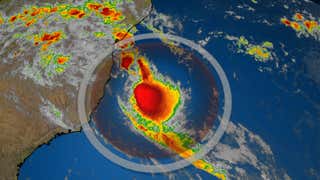
Heavy rainfall is the main threat from Fernand as it makes landfall in northeastern Mexico.
Rainfall totals of 6 to 12 inches (locally, up to 18 inches) are possible, particularly in the higher terrain. That could result in life-threatening mudslides and flash flooding.
A tropical storm warning has been issued for northeastern Mexico from Puerto Altamira to the mouth of the Rio Grande River.
Some locally heavy rain from Fernand will also soak South Texas through Wednesday. Rainfall totals of 2 to 4 inches are possible, with localized amounts up to 6 inches.
A tornado or two is also possible across far South Texas through Wednesday.
Projected Path
(The red-shaded area denotes the potential path of the center of the tropical cyclone. It's important to note that impacts – heavy rain, high surf, coastal flooding and winds – with any tropical cyclone usually spread beyond its forecast path.)
Tropical Storm Gabrielle has developed in the eastern tropical Atlantic Ocean several hundred miles west-northwest of the Cabo Verde Islands.
At this time, computer models suggest that Gabrielle will turn more northwestward and will likely remain over the open waters of the Atlantic into early next week. It is not expected to be a land threat at least through early next week.
Projected Path
(The red-shaded area denotes the potential path of the center of the tropical cyclone. It's important to note that impacts – heavy rain, high surf, coastal flooding and winds – with any tropical cyclone usually spread beyond its forecast path.)
The NHC noted a is expected to emerge off the coast of western Africa on Wednesday and is likely to become a tropical depression by late week or this weekend as it moves across the eastern Atlantic tropics.
It is far too soon to tell if this disturbance will eventually pose any threat to land areas, assuming it develops at all.
Areas to Watch
(The potential areas of tropical development according to the latest National Hurricane Center outlook are shown by polygons, color-coded by the chance of development over the next five days. An "X" indicates the location of a current disturbance.)
The NHC has also highlighted another area of disturbed weather, with clusters of thunderstorms near Bermuda.
Dubbed Invest 92L, the NHC has assigned a medium chance of this system developing in the next five days as it moves slowly toward the northeast, away from Bermuda.


 zpostcode
 Recruit
 weather
 mreligion
 Yellowpages
 sport
sport constellation
 shopping
 name
name game
game directory
 literature
 Word
Word tour
tour furnish
 Lottery
 tftnews
 lyrics
 News
News digital
 car
car dir
dir Edu
Edu Finance


