

US
°C


Kenneth's latest northern Mozambique strike is just the latest in a recent string of strange tropical cyclones.These include a Maui landfall, a track into Michigan and a pair of weird January tropical cyclones.
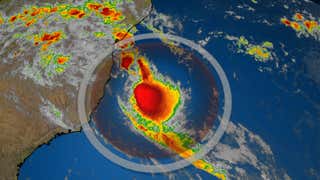
Tropical Cyclone Kenneth's intense landfall in northern Mozambique is just the latest example of a storm occurring in a strange place, during a strange time of year and/or being unusually strong.
(MORE: ForecastLatest News)
Kenneth became the .
Here is a partial list of some of the oddities we've seen with tropical cyclones around the globe in just the last few years.
Just over a month before Kenneth hammered northern Mozambique, Idai pummeled central Mozambique with rainfall and storm surge flooding, claiming over 600 lives in what is the country's worst natural disaster.
According to NOAA's historical database, as reported by Weather Underground's , the country had never previously been hit by two cyclones of at least Category 2 intensity in the same year prior to Idai and Kenneth.
Infrared satellite image at landfall of Tropical Cyclone Idai on March 15, 2019.
Less than two weeks after Idai ravaged Mozambique, Tropical Storm Iba formed off the coast of Brazil, becoming the first south Atlantic tropical storm in nine years.
While tropical storms are very rare in the South Atlantic Ocean, subtropical storms, containing some characteristics of tropical cyclones, actually happen about once a year there.
Tropical Storm Iba swirls off the coast of Brazil in this infrared satellite image on March 25, 2019.
Tropical Storm Pabuk swept into southern Thailand's tourist resorts and coastal villages of the Malay Peninsula just four days into 2019.
While not terribly strong, this was the first known tropical cyclone to landfall in Thailand in either January, February or March, according to the . September and October are the peak months for tropical cyclones, there, usually arriving as weaker tropical depressions after first hitting Vietnam.
In late September and early October 2018, Leslie loafed and lollygagged over the central Atlantic Ocean, making several weird changes in direction before intensifying into a hurricane.
It then was whisked toward the Iberian Peninsula, but lost its tropical characteristics just before .
A wind gust to 109 mph was clocked in Figueira da Foz, Portugal. And in France, Over 14 inches of rain associated with Leslie's remnant led to deadly flooding there, according to the .
Path history of Hurricane Leslie in September and October 2018. Leslie lost its hurricane status just before moving into Portugal.
(NOAA/NHC)
Just three weeks after Hurricane Lane became , Tropical Storm Olivia became the in mid-September 2018.
Most tropical cyclones tracking near Hawaii either weaken considerably upon approach from the east, pass well south, or in more rare cases, hook north into the western Hawaiian Islands.
Olivia was the fourth tropical cyclone to pass near Hawaii in a month's time.
The center of Tropical Storm Olivia tracked over Maui on September 12, 2018.
After a Memorial Day 2018 landfall in the Florida Panhandle, deep moist air and a lack of strong shearing winds kept what was once Tropical Storm Alberto's remnant circulation that it was still a tropical depression on May 30 about 170 miles west of Saginaw, Michigan.
The only other tropical cyclones to have tracked that close to Saginaw since the mid-20th century, according to NOAA, were tropical depressions Arlene and Dennis in 2005, Tropical Depression Candy in 1968 and Tropical Storm Connie in August 1955.
As The Weather Channel senior meteorologist Stu Ostro pointed out, this was also .
Track history of Tropical Storm Alberto in late May 2018.
(Data: NOAA/NHC/WPC)
A pair of tropical cyclones took unusual tracks in the Middle East in the course of less than a week in May 2018,
First, Tropical Cyclone Sagar tracked almost the entire length of the Gulf of Aden before landfalling in far western Somalia on May 19, the
Six days later, Tropical Cyclone Mekunu moved ashore near Salalah, Oman, the first Category 3 landfall in southwest Oman in modern records, dumping over 24 inches of rain in four days in the city.
(FULL RECAPS: SagarMekunu)
Cyclone Mekunu's impacts in Salalah in southwestern Oman on May 26, 2018
(AP Images)
The northeastern Pacific basin's hurricane season starts in mid-May.
In early May 2018, however, a bizarre subtropical cyclone formed in the southeast Pacific Ocean, off the coast of Chile.This appearedto have been a to form over this typically colder stretch of the southeast Pacific Ocean, according to long-term records.
(FULL RECAP: Extremely Rare Southeast Pacific Subtropical Cyclone)
Infrared satellite loop showing what was likely a subtropical cyclone in the southeast Pacific Ocean off the coast of Chile on May 8, 2018.
(NASA)
First, Hurricane Ophelia became the easternmost Category 3 hurricane of record in Atlantic Basin on October 14, 2017, south of The Azores.
Then Ophelia accelerated into Ireland and the United Kingdom two days later.
While it lost its tropical characteristics before reaching Ireland, Ophelia produced wind gusts to 119 mph in Ireland and 86 mph in the U.K. in what was considered their worst storm in 50 years.
Ophelia and the jet stream also transported wildfire smoke from Portugal and Spain, and Saharan dust into the U.K., creating a surreal sight.
It was strange enough when Arlene formed in late April 2017 and became just the second April Atlantic tropical storm in roughly 50 years of records.
But Arlene's path was even stranger.
The jet stream is typically stronger at the northern latitude at which Arlene formed and usually drives storms away to the northeast. However, Arlene was captured by a non-tropical low pressure system to its south and pulled west.
(MORE: Hurricane Season Has Started Early Four Years in a Row)
Thanksgiving and hurricane landfalls didn't really belong in the same sentence – until 2016.
Otto's hurricane landfall was the latest in any calendar year on record in the Atlantic Basin, according to Colorado State University tropical scientist Dr. Phil Klotzbach.
Otto also made a rare crossing from the Caribbean Sea to the eastern Pacific Ocean as an intact tropical cyclone.
(FULL RECAP: Hurricane Otto)
Track history for Hurricane Otto in late November 2016.
Hurricane Alex formed before you could even abandon your New Year's resolutions in one of the strangest starts to a hurricane season in 2016.
Alex became just the second hurricane on record to form in the Atlantic Basin in January. The last hurricane that formed in the Atlantic during January was in 1938, according to NOAA's historical hurricane tracker database.
Alex became the strongest January hurricane on record January 14 when its winds reached an estimated 85 mph. Alex later made landfall on the island of Terceira in the central Azores on January 15 with maximum estimated sustained winds of 70 mph.
(FULL RECAP: Hurricane Alex)
Tiny in the Arabian Sea may have been the unluckiest place in the world in 2015, meteorologically speaking.
First, eyewall lashed the island on Nov. 1. Chapala had become the farthest south Category 4 intensity tropical cyclone on record in the Arabian Sea.
Chapala then made , triggering flooding in the city of Al Mukalla and surrounding areas.
One week later, made a direct hit on Socotra as a Category 2 or 3 storm, according to the India Meteorological Department.
While tropical cyclones in the Arabian Sea aren't unusual at all, this appears to have been the first time on record of back-to-back cyclones hitting Socotra in a week's time.
Tropical Cyclones Chapala (left) and Megh (right) threaten Socotra Island roughly one week apart in late October and early November 2015.
(NASA WorldView images; composite compiled by Stu Ostro)


 zpostcode
 Recruit
 weather
 mreligion
 Yellowpages
 sport
sport constellation
 shopping
 name
name game
game directory
 literature
 Word
Word tour
tour furnish
 Lottery
 tftnews
 lyrics
 News
News digital
 car
car dir
dir Edu
Edu Finance


