

US
°C


An area of disturbed weather near the Southeast Coast is being monitored for possible development. Strong wind shear and interaction with a front should limit development.Despite that, rain, gusty winds, high surf and rip currents will persist along the Southeast coast.
An area of disturbed weather near the Southeast coast has some chance to develop into a subtropical depression or storm through this weekend, but there is one key factor working against that, even though we're still in a core month of the Atlantic hurricane season.
Right now, this system is helping to produce an area of showers and thunderstorms from the coasts of the Carolinas into the adjacent Atlantic waters. These disorganized showers are associated with a weak area of low pressure.
The National Hurricane Center has given this disturbance a low chance to form into a subtropical depression or storm over the next day or so as it inches slowly east-northeast.
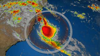
Potential NHC Development Area
(The potential area(s) of tropical development according to the latest National Hurricane Center outlook are shown by polygons, color-coded by the chance of development over the next five days. An "X" indicates the location of a current disturbance.)
The reason this system isn't expected to develop much, despite being over , is wind shear.
Computer forecast models suggest winds above the surface will be strong enough to prevent any area of low pressure from intensifying significantly over the next day or two.
Current Satellite, Wind Shear
(Areas of clouds are shown in white. Areas of strong wind shear, the difference in wind speed and direction with height, are shown in purple. High wind shear is hostile to mature tropical cyclones and those trying to develop.)
The bottom line is while a subtropical depression or storm could form, even if it does, it is unlikely to gain much strength at all, due to wind shear.
A front located near the East Coast will also interact with this system by early next week and should end the opportunity for development.
Despite that, this overall setup will produce some impacts near and along the Southeast coast and possibly farther north into the mid-Atlantic.
The difference in pressure between high pressure over the Northeast and lower pressure associated with the area we're watching will drive persistent onshore winds along parts of the East Coast, particularly the Carolinas.
This could generate high surf and rip currents into the weekend up parts of the Eastern Seaboard.
Keep this in mind if you have beach plans. Rip currents have already claimed, according to the National Weather Service.
(MORE: The Danger of Rip Currents)
There will also be areas of showers and gusty winds near the Southeast coast. Rain and gusty winds from this system will crawl northward into the mid-Atlantic over the weekend.
Localized flooding was reported Saturday morning in parts of the Raleigh metro area.
Heavier, potentially flooding, rain will continue to fall inland over parts of the eastern Carolinas.
Check back with us at weather.com for the latest on this system.
The Weather Company’s primary journalistic mission is to report on breaking weather news, the environment and the importance of science to our lives. This story does not necessarily represent the position of our parent company, .


 zpostcode
 Recruit
 weather
 mreligion
 Yellowpages
 sport
sport constellation
 shopping
 name
name game
game directory
 literature
 Word
Word tour
tour furnish
 Lottery
 tftnews
 lyrics
 News
News digital
 car
car dir
dir Edu
Edu Finance


