

US
°C


The forecast for Isaias has been uncertain for days.There is a forecast factor today that could help bring things into focus.
The track and intensity forecast for Tropical Storm Isaias has had many elements of uncertainty, even days before its formation Wednesday night. But today there could be a pivotal point in the forecast that allows the future strength and track to come more into focus.
One of the reasons for all of the uncertainty is the current center of the storm is expected to track over Hispaniola (the Dominican Republic and Haiti). Land interaction with the higher terrain of this island could make it become disorganized.
However, a new circulation center could form in a concentrated area of rain and thunderstorms located near and northwest of Puerto Rico on Thursday morning. Whether that occurs is uncertain, but we should know if it does once this system moves north of Hispaniola and Puerto Rico.
If it happens, it could cause more shifts to the position of Isaias, and in turn, change the forecast path and intensity of this system.
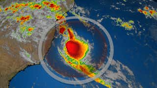
You can see this scenario depicted in the graphic below from early Thursday morning.
The NHC analyzed the center of circulation associated with Isaias to the south of the eastern tip of the Dominican Republic, where the tropical storm symbol is located.
Radar and satellite imagery showed a separate circulation possibly forming to the northwest of Puerto Rico, in the general area of the circle. That circulation was still in the mid-levels of the atmosphere as of Thursday morning, so it had not taken over as the main center of the storm.
Where the circulation center is located once it's north of the Caribbean could help computer model forecast guidance to become more consistent over time.
The bottom line is that it's still too early to precisely determine this system's future track and intensity, especially with regard to the mainland U.S., but the forecast could become more clear once this system moves north of Hispaniola and Puerto Rico.
"We should have a better idea of how strong Isaias will become near the U.S. after reconnaissance aircraft sample the storm and after it passes Hispaniola later today," the NHC said in its forecast early Thursday morning.
As it stands now, Isaias is expected to arrive near eastern Florida Saturday, and possibly central or northern Florida Saturday night into Sunday. That would result in at least some rain and wind impacts in Florida this weekend.
However, the possible outcomes with regard to the mainland U.S. range from a track over Florida or the extreme eastern Gulf of Mexico to a track over at least parts of the U.S. East Coast to a near-miss of the Eastern Seaboard.
This is due to the steering features in the atmosphere - the Bermuda high and an upper-level dip in the wind flow over the Mississippi Valley - as well as the strength of the system. Exactly when Isaias makes that north then northeast turn will be crucial for impacts.
In general...
-Farther west track: If the system is weaker and/or the Bermuda high is stronger and extends farther west.
-Farther east track: If the system is a bit stronger and/or the Bermuda high is not as strong and farther east.
Residents along the Gulf and East Coasts should monitor the progress of this system closely and have their to go, in case they're needed.
The Weather Company’s primary journalistic mission is to report on breaking weather news, the environment and the importance of science to our lives. This story does not necessarily represent the position of our parent company, .


 zpostcode
 Recruit
 weather
 mreligion
 Yellowpages
 sport
sport constellation
 shopping
 name
name game
game directory
 literature
 Word
Word tour
tour furnish
 Lottery
 tftnews
 lyrics
 News
News digital
 car
car dir
dir Edu
Edu Finance


