

US
°C


Hurricane Isaias affected an expansive area from the Caribbean Sea to the Northeast U.S.Rainfall flooding was severe in parts of Puerto Rico and the Dominican Republic.Isaias brought winds and storm surge flooding to Dorian-affected areas of the Bahamas.Isaias grazed the east coast of Florida, but its worst impacts remained offshore.It then roared ashore as a hurricane in North Carolina.Isaias then hammered the Northeast with damaging winds, tornadoes and flooding rain.
Hurricane Isaias ) lashed the Northeast U.S. with destructive winds, tornadoes and flooding rainfall after its North Carolina landfall, a graze of Florida's East Coast, and soaking the Dominican Republic and Puerto Rico with flooding rain.
Isaias developed from a large, vigorous which emerged off the west coast of Africa around .
On July 28, the National Hurricane Center designated the system "Potential Tropical Cyclone Nine", a procedure allowing the issuance of tropical storm warnings for parts of the Lesser Antilles, Puerto Rico and the Virgin Islands before the system had actually become a tropical depression or storm.
Isaias finally became a tropical storm late on July 29, when it was centered about 150 miles south of Ponce, Puerto Rico.
Heavy rain triggered serious in several areas of Puerto Rico. San Juan picked up 6.04 inches of rain from July 29-30. Parts of eastern Puerto Rico picked up over 10 inches of rain in 48 hour estimates from the National Weather Service.
Multiple fallen trees, mudslides and flooding were reported in southwest Puerto Rico, according to local emergency management. was recorded by USGS gauges in several locations in Puerto Rico.
(NEWS: Deadly Isaias Has Left Widespread Damage Across Dominican Republic, Puerto Rico)
Parts of the Dominican Republic picked from Isaias, according to the country's national meteorological office.
Isaias' center hopscotched across Hispaniola, then became a hurricane before brushing through the Inagua Islands.
Isaias then arrived in the Bahamas. Winds gusted to 56 mph at Nassau International Airport, and power was shut off to some parts of the island as a precaution on August 1.
(MORE: Isaias Impacts in the Bahamas)
The center of Isaias moved over northern Andros Island in the Northwest Bahamas, on August 1, where a gust to 69 mph was measured by a U.S. Navy site.
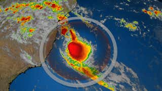
As it was doing so, wind shear temporarily blew thunderstorms away from Isaias, exposing the low-mid level core of Isaias in a .
Winds gusted to 62 mph Sunday morning in Freeport, Grand Bahama, hard hit from Hurricane Dorian in 2019.
What appeared to be at least a was documented by Freeport resident Lean Burrows Sunday morning.
Isaias brushed the coast of Florida and Georgia with rain and gusty winds August 2 and 3.
Isaias strengthened into a hurricane again late on August 3 just hours before it made landfall near Ocean Isle Beach, North Carolina, at 11:10 p.m. EDT as a Category 1 hurricane with maximum sustained winds of 85 mph.
A wind gust to 99 mph was clocked at an elevated weather station at Federal Point, North Carolina. Wilmington, North Carolina, saw wind gusts up to 74 mph.
Hurricane Isaias Landfall
Significant storm surge flooding occurred in Oak Island, North Carolina, which is located just east of where Isaias made landfall.
The storm surge sent the Cape Fear River at Wilmington, North Carolina, .
Storm surge flooding was also reported in Myrtle Beach, South Carolina. Water levels were just over 4.5 feet above normal tide level at , which was the third-highest level observed on record.
While Isaias was technically downgraded to a tropical storm, it spared the Northeast no mercy, propelled by an unusually strong for early August jet stream.
Frequent gusts from 60 to 70 mph were clocked along the Jersey Shore, New York City and Long Island, including a 78 mph gust at New York's Battery Park and in Farmingdale.
Manteo, North Carolina, Norfolk, Virginia, Salisbury, Maryland, and Atlantic City, New Jersey, all clocked wind gusts over 60 mph. The National Hurricane Center reports that a wind gust to 94 mph was measured at a weather station at York River East, Virginia.
Numerous trees were downed - some on vehicles and homes - from Virginia to New England. Telephone poles were snapped in half in Westwood, New Jersey.
had lost power from North Carolina to New England, according to poweroutage.us.
(MORE: Isaias Pounds New York City Metro; Widespread Power Outages in Northeast)
A 2.7-foot storm surge was measured in , Tuesday morning ahead of the arrival of Isaias, though water levels only about 1.4 feet above normal high tide were recorded, there.
Basements were flooded and numerous water rescues were required Tuesday in North Coventry Township, Pennsylvania, between Reading and Philadelphia. King of Prussia, Pennsylvania, picked up 7.74 inches of rain through Tuesday afternoon.
The National Weather Service is forecasting the to crest early Wednesday morning at its second highest level on record, topped only by an October 1869 flood.
Rain-swollen Darby Creek flooded a neighborhood on Philadelphia's southwest side Tuesday afternoon, prompting rescues.
Little Lehigh Creek near Allentown, Pennsylvania, from Hurricane Agnes in 1972, a notoriously destructive Northeast inland flood. , also topped its previous record flood crest which had stood since July 1935.
Multiple roads were flooded, stranding vehicles in Albany, New York, where over 5 inches of rain had fallen.
Water rescues were also performed in Clements and near Hughesville, Maryland, due to flash flooding. One observer near Prince Frederick, Maryland, reported 8.42 inches of rain.
More than 20 reports of tornadoes were received by the National Weather Service from North Carolina to Pennsylvania.
(MORE: The Hurricanes and Tropical Storms That Spawned the Most Tornadoes)
Isaias was the earliest named ninth Atlantic tropical cyclone on record. The previous record was .
Typically the ninth named tropical system occurs in the Atlantic basin in , meaning this year's pace is over two months ahead of average.
(MORE: The 2020 Atlantic Hurricane Season Is on a Record Pace)
The Weather Company’s primary journalistic mission is to report on breaking weather news, the environment and the importance of science to our lives. This story does not necessarily represent the position of our parent company, .


 zpostcode
 Recruit
 weather
 mreligion
 Yellowpages
 sport
sport constellation
 shopping
 name
name game
game directory
 literature
 Word
Word tour
tour furnish
 Lottery
 tftnews
 lyrics
 News
News digital
 car
car dir
dir Edu
Edu Finance


