

US
°C


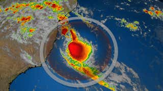
Hurricane Delta intensified over the Gulf of Mexico.But as it nears the Gulf Coast, it may lose some wind intensity.That may not matter much for impacts, like storm surge, rainfall, and strong inland winds.
Hurricane Delta is headed for a landfall along the northern Gulf Coast and, while it may weaken as it nears the coast, that won't matter much for its impacts in Louisiana and elsewhere in the Deep South.
This is a common challenge for meteorologists and emergency managers in communicating hurricane risk. You read a headline or hear about a hurricane weakening and almost instinctively think it may not be that bad. You might let your guard down. Worse yet, you may decide to "ride it out" and ignore evacuation orders.
Here are some reasons why Hurricane Delta will still be dangerous, regardless of any weakening in the hours before landfall.
(MORE: Delta Will Be Record 10th U.S. Landfall in 2020)
Before its potential weakening, Delta intensified into a Category 3 hurricane once again.
That was due to its track over warm water in the southern Gulf of Mexico that fueled the convection around its core and a relative lack of shearing winds that could disrupt the core.
Eventually, however, Delta is expected to track over cooler Gulf water and face higher wind shear as it nears its landfall.
Those factors should weaken Delta.
However, Delta may run out of time to weaken appreciably before slamming ashore. It's expected to be moving at around 15 mph, which is a fairly fast pace for a hurricane.
Furthermore, the stronger Delta becomes through early Friday, the higher intensity it starts from before weakening and the stronger it would then be at landfall.
While its maximum winds are expected to tail off a bit near landfall, the size of Delta's wind field has and may increase a bit more prior to landfall. This is common in hurricanes and tropical storms moving north and feeling the influence of jet-stream winds in higher latitudes.
Delta won't have a giant wind field the likes of, say, Sandy or Ike, but this means a larger area could see at least tropical-storm-force winds capable of tree damage and power outages.
And given Delta's relatively fast forward speed, that could spread these winds well inland over the lower Mississippi Valley late Friday into Saturday.
It's a reminder that hurricanes and tropical storms are not just coastal events.
The storm surge Delta is expected to push into the Gulf Coast is a function of not simply short-term changes in its peak wind speed, but also of the size of its wind field and how much time it churns up the ocean before pushing that water ashore.
So Delta will already be churning up the Gulf of Mexico as it strengthens through early Friday and as its wind field grows. And that Gulf water will be pushed ashore regardless of whether or not Delta's intensity steps down a notch in the hours before landfall Friday.
(MORE: Countdown to a Record; Delta is the 25th Storm of 2020)
The rainfall potential of a tropical storm or hurricane is largely a function of how fast it moves, not any weakening - or strengthening - of its winds.
So changes in its forward speed, not maximum winds, can change a hurricane's rainfall forecast.
In this case, Delta's relatively fast movement will prevent a rainfall event as extreme as Hurricane Sally last month.
But local flash flooding is still quite likely from the Gulf Coast to the lower Mississippi Valley.
The Weather Company’s primary journalistic mission is to report on breaking weather news, the environment and the importance of science to our lives. This story does not necessarily represent the position of our parent company, .


 zpostcode
 Recruit
 weather
 mreligion
 Yellowpages
 sport
sport constellation
 shopping
 name
name game
game directory
 literature
 Word
Word tour
tour furnish
 Lottery
 tftnews
 lyrics
 News
News digital
 car
car dir
dir Edu
Edu Finance


