

US
°C


A tropical depression or storm will likely form in the Gulf of Mexico this week.It's too early to determine where this potential system might track, but the U.S. Gulf Coast and Mexico should follow its progress closely.This may be spawned by a large system called a Central American Gyre and the remnants of a former Eastern Pacific tropical storm.The gyre and tropical storm remnants have already produced major flooding in parts of Central America.
A tropical depression or storm is likely to form in the western Gulf of Mexico this week as the Atlantic hurricane season officially begins.
We've already checked and off this season's list, making this the sixth Atlantic hurricane season in a row with at least one named storm before the official June 1 kickoff. The next storm to form in the Atlantic Basin will be given the name Cristobal.
(MORE: Is An Active Hurricane Season Guaranteed After Two Early Storms?)
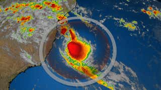
The National Hurricane Center (NHC) has highlighted an area for tropical development in the southwestern Gulf of Mexico, as noted by the circle below. Currently, there is a high chance of development in this area during the next day or two.
This system has been designated Invest 93L by the NHC, which is a
The latest forecast guidance shows that this system is likely to linger in the vicinity of the southwestern Gulf of Mexico for several days this week.
After that time, there is the possibility that it could eventually move northward through the Gulf of Mexico toward the U.S. Gulf Coast by this weekend. It's also possible this system could remain stuck in the southwest Gulf and move inland over southern Mexico.
Since there remains a high degree of uncertainty in the forecast, interests along the Gulf Coasts of the U.S. and Mexico should monitor its progress closely in the week ahead. Check back to weather.com for updates the next several days. If anything, this is a reminder to .
Incidentally, we could be flirting with the record-earliest third named Atlantic storm, which is currently held by .
One thing we know for certain is that there is a serious threat of flooding rainfall and mudslides in Central America and southern Mexico this week.
The NHC says that rounds of additional heavy rainfall could impact southern Mexico, Guatemala, El Salvador, Belize and western Honduras over the next few days.
(MORE: Central America, Mexico Tropical Cyclones Have a Deadly History)
This rainfall is from what's called a Central American Gyre, or CAG. This "gyre" is a large, broad area of low pressure that often forms in late spring and early fall over Central America and the western Caribbean Sea.
This CAG will park itself over far southeastern Mexico and Central America through the week. The remnants of former Tropical Storm Amanda from the Eastern Pacific will also contribute to the heavy rain threat.
Flooding from Amanda and its remnants over the weekend.
Amanda's leftover energy and spin could play a role in triggering tropical development in the southwestern Gulf of Mexico this week.
June isn't one of the more active months of the hurricane season.
Since 1950, only 6% of all storms have formed in June, or an average of one storm every one to two years.
But many of those that do develop in June tend to do so in the Gulf of Mexico or western Caribbean Sea. They have also tended to move northward, meaning they eventually move ashore along the U.S. Gulf Coast.
Tracks of all June tropical depressions, storms and hurricanes from 1950 to 2019.
(NOAA)
Most of these are either tropical depressions or tropical storms because they often don't have as much time to intensify before striking land, and they may be affected by wind shear early in the hurricane season.
Only a dozen of those June developing storms became hurricanes.
The last June hurricane in the Gulf of Mexico was Alex, which made landfall in northeastern Mexico on June 30, 2010, and brought flooding rain to Monterey, Mexico, and the lower Rio Grande Valley of Texas.
Warm water is another factor that may boost tropical development.
While not as warm and somewhat as midsummer, Gulf of Mexico water temperatures are currently warmer than average for this time of year and warm enough to support tropical development. NOAA reported Gulf water temperatures dating to 1910.
(MORE: Atlantic Hurricane Season Outlook)
The Weather Company’s primary journalistic mission is to report on breaking weather news, the environment and the importance of science to our lives. This story does not necessarily represent the position of our parent company, .


 zpostcode
 Recruit
 weather
 mreligion
 Yellowpages
 sport
sport constellation
 shopping
 name
name game
game directory
 literature
 Word
Word tour
tour furnish
 Lottery
 tftnews
 lyrics
 News
News digital
 car
car dir
dir Edu
Edu Finance


