

US
°C


Tropical Depression Grace is bringing rain and gusty winds to the Caribbean, including Haiti.Tropical storm watches and warnings are in effect for parts of the Caribbean.Grace could track from the northwest Caribbean to the Yucatan and the Southwest Gulf later this week.
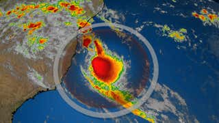
Tropical Depression Grace is tracking through the central Caribbean, where it will bring heavy rainfall and gusty winds early this week, including to earthquake-ravaged Haiti. Grace is expected to become a tropical storm again on Tuesday and later this week could track into Mexico's Yucatan Peninsula and eventually the southwest Gulf of Mexico.
A tropical storm watch is in effect for Haiti, which is in the midst of a recovery effort from Saturday's major earthquake. Tropical storm conditions are possible there into early Tuesday.
Jamaica is also under a tropical storm watch for the possibility of tropical storm conditions there on Tuesday.
Tropical storm warnings and watches are also posted as far west as the Cayman Islands and Cuba. Tropical storm conditions will spread westward midweek.
Haiti and the Dominican Republic could pick up 5 to 10 inches of rain (locally up 15 inches).
This rainfall could trigger flash flooding and mudslides, especially in the mountainous terrain of those countries.
Parts of Jamaica, Cuba and the Cayman Islands might see 2 to 4 inches of rainfall (locally up to 6 inches) through midweek.
Over the northern Yucatan Peninsula, 3 to 6 inches of rainfall is possible with isolated totals up to 10 inches Wednesday into Thursday. There is also an increasing risk of wind and storm surge impacts there Wednesday night and Thursday.
The long-term forecast path for Grace has steadily shifted southward over the past couple of days. Upper-level high pressure to its north is now expected to be strong enough to not allow Grace to move as far north as previously expected.
Grace is forecast to regain tropical storm intensity as it moves through the northwest Caribbean midweek. The storm could then impact Mexico's Yucatan Peninsula with heavy rain and gusty winds by Wednesday night or Thursday.
It's possible that Grace then remerges over the southwest Gulf of Mexico (Bay of Campeche) and approaches northeast Mexico or far southern Texas late week, but details are still uncertain. Grace could grow into a strong tropical storm or a hurricane in the southwest Gulf, but that will depend on how much land interaction weakens the storm and the strength of upper-level winds at that time.
Residents of the western U.S. Gulf Coast and Mexico should continue to monitor Grace's forecast for possible changes over the next few days.
Current Status, Forecast Path
(The red-shaded area denotes the potential path of the center of the system. It's important to note that impacts (particularly heavy rain, high surf, coastal flooding, winds) with any tropical system usually spread beyond its forecast path)
The Weather Company’s primary journalistic mission is to report on breaking weather news, the environment and the importance of science to our lives. This story does not necessarily represent the position of our parent company, .


 zpostcode
 Recruit
 weather
 mreligion
 Yellowpages
 sport
sport constellation
 shopping
 name
name game
game directory
 literature
 Word
Word tour
tour furnish
 Lottery
 tftnews
 lyrics
 News
News digital
 car
car dir
dir Edu
Edu Finance


