

US
°C


For parts of the Northeast, Stella did not deliver as much snow as forecast.However, several aspects of Stella's forecast rang true.
Winter Storm Stella garnered its share of headlines in the Northeast, but not necessarily the ones some meteorologists expected.
The Daily Mail called Stella "."The New York Post declared "."The New York Times – in amore muted form on its online front page – declared "New York City is Spared the Worst as Storm Slams Northeast."
(MORE: |)
Here's how big of a forecast bust Winter Storm Stella really was, and what lessons can be learned for future snowstorms.
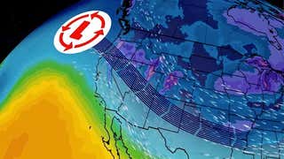
weather.com interactive radar centered on the New York City Tri-State area at 10 a.m. EDT, March 14, 2017, during Winter Storm Stella.
The track of Stella's surface lowwas closer to the Northeast seaboard thananticipated, ushering in warmer air to parts of the Interstate 95 corridor from southern New England to the mid-Atlantic states.
This allowed some sleet, freezing rain and even rain to encroach into this corridorafter an initial round of snow, cutting down some expected snowfall totals along the I-95 corridor.
No doubt a forecast bust was the perception along I-95 and closer to the coast with Stella. Given the hype this storm received, it's understood why tens of millions thought Stella was a dud if it didn't shut down the city.
Below was The Weather Company/weather.com's forecast prepared on Monday, one day before Stella began hammering the Northeast.
Winter Storm Stella Northeast forecast made on March 13, 2017, one day before arriving into the Northeast.
Note the forecast snowfall intervals for Boston (Logan International Airport), New York City (Central Park), Philadelphia (Philadelphia International Airport) and Washington D.C. (Reagan National Airport), while a general swath of at least a foot of snow was expectedinland from I-95.
Clearly, our forecast snowfall was too high for the immediate I-95 corridor. What was not shown above wasour snowfall forecasts on the afternoon of March 13, which nudged upward above a foot in New York City.
For several days prior to Stella's arrival, meteorologists at weather.com, The Weather Channel and the National Weather Service mentioned the substantial uncertainty along the I-95 corridor.
"We knew all along there would be a changeover for the coastal cities," said weather.commeteorologist . "This slight jog left in the track wasn't a huge change to the forecast, (it) just brought the changeover to a mix (sleet/ice) or rain a little earlier than expected – enough to kill the blizzard warning for NYC."
(MORE: )
Despite all that, – not too far below our forecast. Furthmore, as The Weather Channel senior meteorologist Stu Ostro pointed out, one location just 4 miles from The Bronx picked up over a foot of snow.
In parts of the I-95 corridor, it wasn't snow or rain, but rather an ice storm early Tuesday that, when coupled with wind, led to tree damage and power outages.
Don't tell anyone in the Northeast's interior that Stella underachieved.
, particularly in a corridor from central Pennsylvania and northern New Jersey into central New York and Vermont.
, setting an all-time snowstorm record in Binghamton, New York.
Winds gustedover 60 mph along parts of the coast, from the Jersey Shore to Long Island and the southern New England coast, as a rapid strengthening of the low-pressure center.
, topping 3 feet above normal tides at Atlantic City, which prompted water rescues.
(MORE: )
The video above was from Ocean City, New Jersey, during high tide on March 14, 2017.
Was our snowfall forecast for Boston, New York, Philadelphia and Washington D.C. too high? Yes.
Was Stella a forecast bust overall? Based on all the impacts listed above, we have to say no.
Going forward, here's what you should remember about snowfall forecasts.
Most National Weather Service offices will not issue a snowfall total forecast – for example, X to Y inches forecast for Anytown – until it's within 48 hours of an event.
This is because, as we saw with Stella, subtle changes in the track of low pressure, and can be difficult to forecast, even 1 to 2 days before the storm, by today's most sophisticated numerical forecast models.
At weather.com, we'll often post a snowfall outlookwithout snowfall totalsto give you a general idea of where the heaviest snowmayfall. Below is an example from the weekend before Stella hit the Northeast.
Winter Storm Stella Northeast snowfall outlook made on March 11, 2017, three days before arriving into the Northeast.
What we typically tell youseveral days away from a potential storm is:
There is a possibility of a storm.The storm may occur during a given time frame.Details like snow/icetotals for specific cities are to be determined.
This is the most important point. You need to check back frequently for updates.
A forecast issued two days before the storm isn't gospel. As the storm gets closer, the forecast frequently changes.
For example, here is an animation showing 16 consecutive model forecasts for Tuesday at 2 p.m. EDT, produced from four days prior to the snowstorm until the morning of the snowstorm, courtesy of Levi Cowan at tropicaltidbits.com. The snowy areas are shown in blue, while rainy areas are shown in green, yellow and orange.
16 consecutive GFS model forecasts for 2 p.m. EDT, March 14, 2017, of Winter Storm Stella in the Northeast. Areas of snow are shown in blue. Areas of rain shown in green, yellow and orange. The model forecasts were generated from March 10 (first frame of animation) through March 14 (last frame).
(Levi Cowan/tropicaltidbits.com)
Notice all the precipitation areas jostling around near the Northeast coast, from a soaking rain to heavy snow? That's a common problem in amodel forecast several days in advance.
In practice, meteorologists incorporate data from not just one forecast model, but a consensus from multiple models – including clusters of models called ensembles – to adjust their forecasts.
These groups of modelsolutions often change, sometimes radically, from day to day.
If the forecast for your area changes significantly, as we mentioned earlier, it may be a subtle, 50-mile-or-less shift in the track of low pressure that makes all the difference.
Consider Stella on Tuesday morning; just a small distance separated rain in western Long Island from over a foot of snow and whiteout conditions in the northern New Jersey suburbs.
Long disclaimers when installing a new app can makeeyes glaze over, but forecasters will spell out important details in their videos or columns you may not get in a graphic alone.
For example, weather.com meteorologist made an important point atop a Monday morning Stella forecast article.
In short, you may read or hearabout trendsin the forecast, which may have an impact on the ultimate outcome in your location.
Similar to digging deep into a news storyrather than just reading a headline, listening to the forecaster givesthefull picture, not only on what the forecast is right now, but also the uncertainty in the forecast and how it may change.
Virtually all snowstorm forecasts havechallengesand will continue to test the minds ofmeteorologists. It's truly a humbling line of work and, personally, I've busted more forecasts than I care to admit.
However, based on the evidence, Stella wasn't nearly as big of a forecast whiff as you may hear.
MORE ON WEATHER.COM: Winter Storm Stella
People struggle to walk in the blowing snow during a winter storm Tuesday, March 14, 2017, in Boston. (AP Photo/Michael Dwyer)


 zpostcode
 Recruit
 weather
 mreligion
 Yellowpages
 sport
sport constellation
 shopping
 name
name game
game directory
 literature
 Word
Word tour
tour furnish
 Lottery
 tftnews
 lyrics
 News
News digital
 car
car dir
dir Edu
Edu Finance


