

US
°C


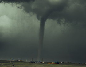
Yet another nor'easter has nailed New England, the third since March 2.Blizzard conditions were reported in parts of Massachusetts, Maine and Rhode Island.
Snowfall first developed on March10 from a southeastward dipping disturbancein the Plains. By March 11, light snow fell across the mid-Mississippi Valley, including the St. Louis metro area, then spread into the Appalachians later March 11into March 12.
(MORE: )
Skylar hammered the Northeast corridor on Tuesday, Mar. 13, with heavy snow, damaging winds and minor coastal flooding as it bombed out off the coast.
Skylar has dumped over a foot of snow in parts of Massachusetts, Rhode Island, Connecticut, New York, New Hampshire, Vermont, West Virginia and Maine. Seven of those states have picked up more than 20 inches of snow.
The top snowfall total so far is 30 inches in Little Lyford Pond and Holden, Maine. Additional snowfall reports can be foundin the next section.
This storm was the .
began Marchwith destructive winds, heavy snow and severe coastal flooding in the Northeast. Last week, dumped heavy snow that led to additional downed trees and power outages.
(Storm Impacts: )
Up to 10.5inches of snow was reported in the Lexington, Kentucky, metro area March 12, .
Trees were downed by the weight of the heavy, wet snow in Beattyville, Lawrenceburg, Mt. Vernonand Perryville, Kentucky, early March 12.
Rain changed to light snow in the Nashville metro early March 12, with some north metro suburbs picking up an inch or two of wet snow, leading to a slippery morning commute.
Snow was seen sticking to roads , and Richmond, Virginia, during the afternoonand early-evening of March 12, .
Accumulating snow was observed as far east as Virginia Beach, Norfolk, Virginia, and eastern North Carolina on the evening of March 12.
Roads were slick in Greensboro, North Carolina, midday March 12, causing at least .
In West Virginia, snowfall rates of 3 inches per hour were measured in Camden-on-Gauley and Summersville. Calvin, West Virginia, had picked up 18 inches of snow through March 12.
Snowfall rates accelerated as Skylar pivoted into the Northeast on Mar. 13, with rates as high as 3.25 inches per hour were recorded in New England. The heaviest snow fell from eastern Massachusetts to central and coastal Maine.
New were set on Tuesday in Boston where 14.5 inches fell and in Worcester where 21.8 inches accumulated.
Here are a few selected snowfall totals by state throughearly Wednesday afternoon:
Connecticut:23 inches in Oakdale; 21.2 inches near Norwich; 15.5 inches in New London Iowa: 4.5 inches near Centerville Illinois: 6 inches in Herald Indiana: 6 inches nearLeopold Kentucky:Up to 10.5 inches near Lexington; 2.4 inches in Louisville Maine:30 inches in Little Lyford Pond and Holden; 20.9 inches in Bangor; 20 inches in Bar Harbor; 14 inches in Portland Maryland:7 inches in Deep Creek Lake; 4.3 inches in Oakland Massachusetts:29.5 inches in Wilmington; 27.8 inches in Uxbridge; 26.6 inches in Milford; 21.8 inches in Worcester; 14.8 inches in Boston Missouri: 5 inches nearWright City New Hampshire:28.6 inches near Deerfield; 28 inches in Middleton; 27 inches in Danville and Raymond New Jersey:7.5 inches in Highland Lakes; 4.8 inches in Greenville New York:23 inches in Ellenburg; 18.3 inches in Southampton (Long Island); 17 inches in Chateaugay (Upstate New York) North Carolina:9inches at Mt. Mitchell State Park; 8 inches in Boone; 2 inches in Winston-Salem Ohio: 3.5 inches in Hiram Pennsylvania:8.5inches in Drakes Mille; 6 inches in Union City Rhode Island:25.1 inches inNorth Foster; 21 inches in Burrillville; 20 inches in Woonsocket; 12.3 inches in Providence Tennessee: 7 inches at Roan Mountain;6 inches in Limestone Vermont:29.5 near Graniteville; 23 inches in Woodford; 13.5 in East Montpelier; 9.2 inches near Burlington Virginia: 11.8 inches near Mustoe; 6.1 inches in Blacksburg West Virginia: 18inches in Calvin; 4 inches in Charleston
Skylar rapidly intensified late March 12 into March 13 off the East Coast, as heavy snow and gusty winds spread into New England. Pressure dropped as low as 966 mb on the afternoon of Mar. 13.
Blizzard conditions have been confirmed in , ,as well as , and , according to the National Weather Service.
The NWSwhen the following conditions are met for at least three hours: sustained winds or frequent gusts to at least 35 mph and considerable falling and/or blowing snow that frequently reduces visibility to less than a quarter-mile.
The last time a blizzard had been observed in Boston was during Winter Storm Niko Feb. 7-9, 2017, NWS-Boston reported.
Windsgusted from 35 to 50 mph Tuesday at Boston's Logan Airport. Midday Tuesday, winds gusted as high as 81 mph in East Falmouth, Massachusetts, while Hyannis, Massachusetts, clocked a 79-mph wind gust and Nantucket Islandgusted to 77 mph. Reports of trees downed have come in from Long Island and Connecticutto Maine.
Nantucket observed a 3-foot storm surge during Tuesday morning's (Mar. 13) high tide, since 1963. Boston's storm surge was around 2.8 feet at high tide Tuesday morning.
Peter Pelletier removes branches from the tree that fell onto his car parked at his home in Fairhaven, Mass., Wednesday, March 14, 2018. A third major snowstorm in two weeks buried some New England towns beneath 2 feet of snow. (Peter Pereira/Standard Times via AP)


 zpostcode
 Recruit
 weather
 mreligion
 Yellowpages
 sport
sport constellation
 shopping
 name
name game
game directory
 literature
 Word
Word tour
tour furnish
 Lottery
 tftnews
 lyrics
 News
News digital
 car
car dir
dir Edu
Edu Finance


