

US
°C


A winter storm will produce significant snow in the northern Plains, Upper Midwest and Rockies through the weekend. Let's start with a breakdown of the snow forecast and then follow up with a look at the bone-chilling temperatures.
Midwest Radar
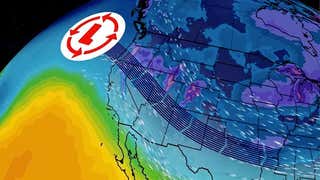
A dip in the jet stream, or trough, has dug south into the northern Plains this weekend.
(MAP: Sunday's jet stream pattern)
With cold air in place,lift in the atmosphere provided by disturbances embedded in the trough is will squeeze out snow in the central and southern Rockies, northern Plains and Upper Midwest through early Monday, including Minneapolis/St. Paul, Minn., Fargo, N.D., Duluth, Minn., Marquette, Mich., and Green Bay, Wis.
Plowable snow, the heaviest snow of the season so far for some, will spread from the Dakotas and Minnesota to Wisconsin and northern Michigan through Sunday, lingering into early Monday.
The heaviest storm total accumulations will occur in a stripe from northeast South Dakota through central Minnesota into far northwest Wisconsin, where 6-12 inches can be expected, including the Twin Cities metro area.
48-Hour Snow Forecast
Snow, possibly heavy at times, will continue through Sunday in the Twin Cities, so keep this in mind if you have travel plans. While snow should taper off by Monday morning, leave extra time for the Monday morning commute, due to accumulated snow, particularly on side streets.
(MAP: Driving difficulty index)
Strong north to northwest winds will produce blizzard conditions, at times, with considerable blowing snow reducing visibilities through Sunday in parts of the northern Plains.
In fact, blizzard warnings are now posted for portions of south-central North Dakota, north-central/northeastern South Dakota and a part of southwestern Minnesota. This includes a stretch of I-29 in northeast South Dakota.
(MORE: Midwest snowless streaks breaking records)
Highs Sunday
The shot of cold air invading the central states this weekend will be a classic "Blue Norther'", in the lexicon of meteorology, nosediving southward through the High Plains into Monday.
Temperatures will struggle to get out of the single digits, teens and 20s in the northern Plains and along the Front Range Sunday. Wind chills may dip as low as 20 to 30 degrees below zero in parts of the Dakotas.
(MAPS: Temperatures | Wind chills)
Highs in the 10s and 20s will also sweep into the Upper Midwest and northern Great Lakes by Monday.
Colder air will eventually arrive in the eastern states Tuesday after a mild weekend, particularly in the South.
(HIGHS MAPS: Sun | Mon | Tue)


 zpostcode
 Recruit
 weather
 mreligion
 Yellowpages
 sport
sport constellation
 shopping
 name
name game
game directory
 literature
 Word
Word tour
tour furnish
 Lottery
 tftnews
 lyrics
 News
News digital
 car
car dir
dir Edu
Edu Finance


