

US
°C


Eboni's snow was felt from the Sierra to the Midwest and New England. Eboni brought blizzard conditions to parts of the Plains on Dec. 27.The winter storm forced the closure of interstates from the Southwest to the Plains.
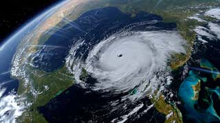
Winter Storm Eboni was a cross-country winter storm that began its trek in the Pacific Northwest, then spread snow through the Southwest, blizzard conditions to the Plains and then snow and ice to the Midwest and New England.
(EBONI NEWS: Winter Storm Eboni Turns Deadly, Forces Highway Closures)
Here's a day-by-day recap of Winter Storm Eboni:
Dec. 24-25
The low-pressure system that became Winter Storm Eboni came ashore near the California/Oregon border on Christmas Eve with an area of snowfall and coastal rain.
Eboni brought more than a foot of snow to the Sierra Nevada on Christmas Eve into early Christmas morning.
The system created a dip in the jet stream on Christmas over the Southwest, where Eboni dropped snow across the Four Corners and the Tetons.
Dec. 26
Eboni intensified as it reached the southern and central Plains.
A portion of Interstate 25 between Albuquerque and Santa Fe, New Mexico, was closed as heavy snow accumulated on the highway, causing motorists to get stuck as they attempted to drive up La Bajada Hill, KOAT-TV reported. The road was reopened a few hours later , according to KRQE.com.
Dec. 27
Interstate 80 westbound was forced closed in Nebraska between Kearney and North Platte during the afternoon hours while Interstate 80 eastbound had to close from North Platte to Lexington, Nebraska, due to .
Nearly all flights were canceled due to blizzard conditions in the eastern North Dakota city.
Blizzard conditions were also observed during the morning hours in western Kansas, stranding motorists near Scott City and Leoti. Power outages were reported around Garden City, Kansas.
in Kansas late morning between Colby and WaKeeney. between Goodland and Hays, Kansas, during the afternoon.
In southwestern and central Nebraska, whiteout conditions were reported in the morning near Culbertson and Arcadia.
Dec. 28
Snow showers and gusty winds lingered in the northern Plains and upper Midwest in the morning while a wintry mix of snow, sleet and freezing rain spread into parts of upstate New York and New England.
Slick travel conditions due to freezing rain were observed in some areas, particularly from northeastern New York into portions of Vermont and New Hampshire. A brief wintry mix was observed as far south as central Massachusetts.
Eboni wrapped up across the northern Great Lakes and New England on the evening of Dec. 28 as warmer air turned snow and ice over to rain from south to north.
Here are select snowfall reports:
Arizona: 7 inches in EagarCalifornia: 12 inches at Northstar ResortColorado: 11 inches near PlacervilleIdaho: 4.5 inches near Chubbuck; 4 inches in PocatelloKansas: 9.5 inches in Hoxie; Blizzard conditions Thursday morning in western KansasMaine: 2 inches near FarmingtonMichigan: 4 inches in Hancock, Chassell and AllouezMinnesota: 24 inches in Finland; 13.1 inches in Duluth; 2.9 inches at Minneapolis/St. Paul International AirportMontana: 5.5 inches in CircleNebraska: 12 inches near Santee; 3.8 inches in Kearney; 3.3 inches near North Platte; Blizzard conditions Thursday morning in southwestern NebraskaNevada: 18 inches at Wild Horse (elev. 6,239 feet)New Hampshire: 2 inches near Jefferson; 0.20 inches of ice near NashuaNew Mexico: 9 inches near Llano LargoNew York: 0.10 inches of ice in Holland PatentNorth Dakota: 11 inches in Anamoose and George Lake; 9 inches near Fargo; 7.5 inches in Bismarck; Blizzard conditions Thursday afternoon in eastern North DakotaOklahoma: 10 inches in GuymonOregon: 8 inches near CornucopiaSouth Dakota: 11.5 inches near Milbank; Blizzard conditions Thursday afternoon in eastern South DakotaTexas: 8 inches in TexhomaUtah: 6 inches in Harrisville; 4.5 inches in Salt Lake CityVermont: 1 inch near Worcester; 0.10 inches of ice near NashvilleWisconsin: 5.1 inches near SuperiorWyoming: 8 inches in Pahaska
The warm side of Winter Storm Eboni also produced heavy rainfall across the South.
Up to 11.5 inches of rain was recorded in Mississippi near Clara, while water rescues were needed due to flooding.
A stripe from southern Louisiana to southern Mississippi and western Alabama received more than 5 inches of rain on Dec. 27-28.
Flooding was also reported in northern Georgia, Tennessee and North Carolina.
Errol Behm uses a scarf to shield his face from the blowback of snow caused by the gusty winds as he clears a sidewalk with a snowblower near Fourth Street, Thursday, Dec. 27, 2018, in Bismarck, North Dakota. (Mike McCleary/The Bismarck Tribune via AP)


 zpostcode
 Recruit
 weather
 mreligion
 Yellowpages
 sport
sport constellation
 shopping
 name
name game
game directory
 literature
 Word
Word tour
tour furnish
 Lottery
 tftnews
 lyrics
 News
News digital
 car
car dir
dir Edu
Edu Finance


