

US
°C


A winter storm layed down an expansive mess of snow and ice from the Plains and upper Midwest to northern New England between Jan. 10 and Jan. 12, 2020.
The storm was called Winter Storm Isaiah by The Weather Channel.
This winter storm began to bring snow and ice to the Central Plains early on Jan. 10.
The first snow began in parts of South Dakota, Nebraska, Colorado and New Mexico as a low-pressure system strengthened over the central and southern Rockies. In advance of that system, a stream of heavy rain lined up from the Southern Plains to the southern Great Lakes.
During the afternoon of Jan. 10, snow filled in from the panhandles of Texas and Oklahoma to Nebraska, Iowa and southern Minnesota, while icing became problematic from Kansas to southern Iowa.
There were a few reports of thunder in the wintry precipitation in eastern Kansas and northwestern Missouri at times.
Ice accumulated on trees and grass in Topeka, Kansas, and slowed down traffic on roadways and bridges across eastern Kansas.
From has been reported in parts of Kansas, northwestern Missouri, Iowa, northern Illinois, southern Wisconsin and Michigan, leading to hazardous travel, particularly on elevated roads and bridges.
(NEWS: Hundreds of Flights Canceled, Electricity Knocked Out)
Snowfall totals were rather modest, generally in the , from Missouri and southern Kansas into southeastern Nebraska, Iowa, southern Wisconsin and northern Lower Michigan.
But some notable snow also fell in more southern locales of the Plains states. On the morning of Jan. 11, snow was reported as far south as Oklahoma, where .
A burst of snow at the tail end of the storm dumped a quick 2 to 3 inches of snow in the far northern suburbs of Fort Worth, Texas, and in Frisco, site of Jan. 11's FCS National Championship football game.
While only 0.2 inches, Dallas-Fort Worth International Airport picked up its on the morning of Jan. 11.
Two inches of snow also was measured in Lubbock, Texas, overnight Jan. 10 into early Jan. 11, prompting . Flakes were also seen in , at the National Weather Service office early Jan. 11.
Almost 4 inches of snow also fell near the Kansas-Oklahoma border in .
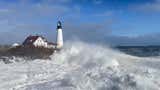
in parts of the Plains, Great Lakes and much of the East as the low-pressure system intensified. Gusts over 50 mph were recorded on the morning of Jan. 11 at Chicago's O'Hare Airport and Milwaukee's Mitchell Field.
As if that weren't enough, these strong winds blowing over the Great Lakes, some of which were at record- or near-record-high levels, led to areas of lakeshore flooding.
These battering waves reportedly on the morning of Jan. 11 and apparently reached some residential structures in the Rogers Park neighborhood, according to the National Weather Service.
According to the NWS-Chicago, a weather sensor at Calumet Harbor measured a water level 2 to 3 inches within the all-time record there, set in August 1986.
The warned large, battering waves "could exacerbate already significant beach and shoreline erosion" and could heavily damage vulnerable structures.
It also said "significant lakeshore flooding is expected. Strong north to northeast winds gusting up to 40 to 50 mph will build waves to 12 to 18 feet with occasional waves up to 23 feet."
On the afternoon of Jan. 11, lakeshore flooding was reported at Whihala Beach in Whiting, Indiana, where water was seen .
The winter storm moved into northern New York and northern New England overnight Jan. 11 into Jan. 12.
Heavy snow was reported across northern Maine, while significant ice accumulations occurred in other parts of northern New England and northern New York.
Illinois: 4 inches in Bath and Havana; 2.1 inches in ChicagoIowa: 4.3 inches in Indianola; 4 inches in Des MoinesKansas: 5 inches in Fall River Lake, Sedan and Yates CenterMichigan: 4 inches in East JordanMissouri: 5 inches in WarrensburgNebraska: 3.5 inches in BeatriceNew Mexico: 8 inches in CloudcroftTexas: 3 inches near Breckenridge, Decatur and Krum; 2 inches in LubbockWisconsin: 4.4 inches near Dodgeville
Illinois: 0.25 inches in RockfordIowa: 0.25 inches in CentervilleKansas: 0.25 inches in HillsboroMichigan: 0.25 inches in Grand RapidsMissouri: 0.33 inches in TrentonNew York: 0.59 inches in SaranacVermont: 0.75 inches in AlburghWisconsin: 0.30 inches in Monticello
The Weather Company’s primary journalistic mission is to report on breaking weather news, the environment and the importance of science to our lives. This story does not necessarily represent the position of our parent company, .


 zpostcode
 Recruit
 weather
 mreligion
 Yellowpages
 sport
sport constellation
 shopping
 name
name game
game directory
 literature
 Word
Word tour
tour furnish
 Lottery
 tftnews
 lyrics
 News
News digital
 car
car dir
dir Edu
Edu Finance


