

US
°C


Temperatures are expected to be near or above average in the South this winter. The northern tier has the highest odds of seeing colder-than-average temperatures.Precipitation will split between wet across the northern states and dry through the South.A weak La Niña should play some role in the weather conditions this winter.
Winter 2017-18 will feature a nationwide split between colder and wetter-than-average conditions in parts of the northern stateswhile the southern tier sees warmer and drier-than-average conditions overall, according to an updated outlookreleased Friday by The Weather Company, an Business.
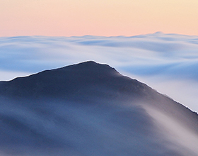
Pedestrians walk in the snow and wind on Feb. 9, 2017, in the Brooklyn borough of New York City during Winter Storm Niko.
(Spencer Platt/Getty Images)
Weak La Niña conditionshave officially developedand have a 65 to 75 percent chance of persisting through the winter months, according to NOAA,potentially influencing the weather conditions we see in the United States this winter.
(MORE:)
Signs of La Niña's influence may be evident already in November, with colder-than-average temperatures dominating the .
Winter (December through February) temperature outlooks from both The Weather Company and NOAA feature some similarities to what is typically expected in a LaNiña winter.
“As is typical in La Niñabase state winters, we expect the greatest risk of cold early in the winter in the eastern U.S., with the cold retreating towards the Pacific Northwest as the winter progresses,” said, chief meteorologist with The Weather Company.
(MORE:)
La Niña, El Niñoor the lack of either, known as the neutral phase, is only one large-scale forcing on the atmosphere. It is notarbiter in determining whether a season is wet, dry, cold or warm. Other factors are in play, includingatmospheric blocking.
Below are the national details on what to expect.
The highest odds of below-average temperatures are from the Pacific Northwest to the upper Mississippi Valley, also extending into the Northeast due to increased risks of "blocking" weather patterns featuring jet stream dips getting stuck over the eastern states.
The rest of the U.S. is expected to see near- or above-average temperatures this winter. The warmest temperatures, relative to average, will likely be found over the south-central states and parts of the Desert Southwest. A mild winter is typical throughout the South during LaNiña winters.
The red contour in the south-central states corresponds to higher probabilities of above-average temperatures. The light blue and orange contours show where temperatures may be slightly below or slightly above average, respectively.
(The Weather Company, an Business)
Since last winter featured a weak LaNiña, Crawford saidit’s reasonable to use it as an analog for this winter’s forecast.
Last winter, much of the East into the South and Midwest had one of their warmest winters while the Northwest was colder than average.
Two of thetop-10 warmest wintersdating to 1895 in the Lower 48 have occurred in back-to-backyears. Last winter was the .
(MORE: )
However, Crawford cautioned against simply assuming last winter will repeat itself exactly this winter, especially ifit hasmore blocking weather patterns in the upper atmosphere as mentioned above.
One particular blocking pattern would feature a southward dip in the jet stream east of the Rockies that could “lock in” for extended periods of time, leading to shivering results.
“Analysis of other analog sets and statistical models suggest increased blocking risks relative to last year, which isn't saying much, but should result in a colder winter,” Crawford added.
On the other hand, if a less-blocking scenario panned out, conditions would be similar to last year with below-average temperatures confined to the Pacific Northwest again.
Keep in mind, these outlooks are overall trends over a three-month period from December through February.
An individual cold front or an upper ridge of high pressure can lead to a period of colder or warmer weather, respectively, that bucks the overall three-month trend. The same front or area of high pressure can bring a brief period of enhanced precipitation or dry spell that may or may not be indicative of the overall trend that is forecast.
NOAA's precipitation forecast also has some correlation with what is expected in aLa Niña winter.
Portions of the Ohio Valley, Great Lakes and northern Rockies have the highest odds of above-average precipitation this winter. Depending on temperatures at any given time this winter, we could see increased odds of snow in those regions.
(MORE: )
Meanwhile, the South could be in for a dry winter, which is typical during La Niña. If this pans out as forecast, there is the possibility of growing drought conditions, also givinga boost to wildfire danger in this region next spring.
Dark-green shaded areas in the Great Lakes, Ohio Valley and the northern Rockies have the greatest odds for above-average precipitation this winter. Locations highlighted in dark brown across the South have the highest probability of drier-than-average conditions. Areas not shaded have an equal chance of seeing precipitation below, above or near average.
(NOAA)
La Niña/El Niño, the periodic cooling/warming of the equatorial eastern and central Pacific Ocean, can shift weather patterns over a period of months, bringing the possibility of more sustained warm, cold, wet or dry weather in parts of the world.
When sea-surface temperatures are cooler than average by at least 0.5 degrees Celsius, along with consistent atmospheric indications, a La Niña is considered to be in place.
The black box highlights the cooler-than-average sea-surface temperatures near the equator, indicating La Niña conditions, on Nov. 9, 2017.
NOAA saidoceanic and atmospheric signals in October and early November are consistent with a weak La Niña. You can see the strip of cooler-than-average sea-surface temperatures near the equator as of early November in the graphic above.
The peak atmospheric response to the equatorial Pacific anomalies tends to occur in the Northern Hemisphere's winter months. This is why the development of La Niña or its counterpartEl Niñoreceives a large amount of attention prior to winter.
(MORE: )
During last winter's weak La Niña, the West and upper Midwest had one of their wettest winters on recordwhile a large swath of the East, South and Midwest had one of their warmest winters.
Winter 2015-16 featured a that had major weather pattern impacts around the world.
It's important to note thatLa Niña/El Niño is not a factorevery winter since, many times, equatorial Pacific sea-surface temperatures run near average, meaning so-called neutral conditions exist.


 zpostcode
 Recruit
 weather
 mreligion
 Yellowpages
 sport
sport constellation
 shopping
 name
name game
game directory
 literature
 Word
Word tour
tour furnish
 Lottery
 tftnews
 lyrics
 News
News digital
 car
car dir
dir Edu
Edu Finance


