

US
°C


It has been almost three years since the U.S. has seen this much snow cover in November.Some of this early season snow has fallen in some unusual locations.
Snow cover in the U.S. early this week is the most expansive since for November since 2015 and is located in some unexpected locations.
(MORE: )
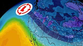
Early on Nov. 13, the area of the U.S. covered by snow was 29.4 percent which was the greatest area of the U.S. covered by snow in November in almost three years, based on analysis from NOAA's .
The last time there was agreaterarea covered with snow in the U.S. in November was in 2015 when Nov. 27-30 saw of the U.S. with snow on the ground.
Snow cover analysis as of 1 a.m. EST, Nov. 13, 2018.
(NOAA/NOHRSC)
Many snow-covered areas are where you would expect for mid-November, including the Rocky Mountains, northern Plains, Great Lakes and northern New England.
However, the snow also extended farther south into the central and southern Plains with snow on the ground as far south as the Texas Panhandle.
The snow in the more southern regions has been unusual.
This year is only the in Kansas City that three measurable snowfall (at least 0.1 inches) have occurred by Nov. 12.
Wichita,Kansas, measured 2 inches of snow on Nov. 12 and when added to the 0.7 inches that fell on Oct. 14, it is the snowiest start to the snow season on record.
The 4.4 inches of snowfall in Amarillo, Texas, on Nov. 11-12 was accompaniedby and is a little earlier than the average first snowfall of Nov. 24.
On Tuesday, and broke the record for earliest observed snow there. A dusting of snow was also seen at .
In addition,sleet was reported as far south as near the Mexican border on Tuesday.
Early Wednesday, the was observed in Monroe, Louisiana, breaking the previous record by 10 days.
The U.S. snow cover is almost double what it was last year on Nov. 13 when just 16.5 percent of the U.S. was covered in snow. In mid-November 2017 the snow cover was mainly confined to the northern tier and stretched into the central Rockies.
Season-to-datesnowfall has been noticeably more widespread this year compared to last year.
The reason for the difference in snow cover is the upper-level weather pattern that has dominated the U.S. recently.
The jet stream has generally taken a southward dip over the central and eastern U.S., allowing to plunge southward. This pattern has also allowed several disturbances to track across the U.S. and with cold air in place, snow has resulted at times.


 zpostcode
 Recruit
 weather
 mreligion
 Yellowpages
 sport
sport constellation
 shopping
 name
name game
game directory
 literature
 Word
Word tour
tour furnish
 Lottery
 tftnews
 lyrics
 News
News digital
 car
car dir
dir Edu
Edu Finance


