

US
°C


A blast of cold air and a diving jet stream will set the stage for snow.Snow has already triggered road closures in parts of the Rockies.Additional snow will blanket areas from the Rockies to the upper Midwest.This will be the season's first snow for some.
Snow will continue to blanketparts of the Rockies, Plains and upper Midwest into Sunday nightas far south as New Mexico and the panhandles of Oklahoma and Texas, over a month ahead of the average first snowfall in those locations.
Snow continues to fall from parts of northeastern New Mexico and the Texas and Oklahoma panhandles into eastern Colorado, Kansas, southeastern Nebraska, Iowa, southeastern Minnesota and portions of Wisconsin.
(MAP: )
Residents of the Texas Panhandle observed snow and ice Sunday, which led to slick travel across parts of the area – a rare occurrence in mid-October.
Parts of Montana, northern Wyoming and the Black Hills of South Dakota have picked up 6 to 12-plusinches of snow, including Sheridan, Wyoming (6 inches), (10 inches), and Custer, South Dakota (6 to 10 inches).
An observer 5 miles west of Red Lodge, Montana, measured 15.6 inches of snow, and an observer 16 miles south of Sheridan, Wyoming, measured 13.5 inches, according to the National Weather Service.
A band of moderate snow Saturday night into Sunday morning dumped 4 to 8inches of snow from southeastern Wyoming into far northern Colorado and the Nebraska Panhandle.
Over 7 inches of snow was reported on the south side of Boulder, Colorado, Sunday morning, Oct. 14, 2018.
(Matthew Kelsch)
FortCollins, Boulderand Loveland, Colorado, picked up 4to 7inches of snow through Sunday morning. Up to 11 inches of snow fell in the foothills west of Boulder.
Cheyenne, Wyoming, picked up 4 to 8 inches of snowwhile up to 8 inches of snow was reported in Scottsbluff, Nebraska.
Saturday night and early Sunday morning due to poor winter driving conditions in southeastern Wyoming.
The combination of snow and strong winds triggered some sporadic power outages in Torrington, Wyoming, Saturday night, according to the National Weather Service.
Denver International Airport measured 2.7 inches of snow midday Sunday, with roads mainly wet across the metro area.
Meanwhile, the first measurable snowfall of the season fell early Sunday in , South Dakota, with some parts of the city picking up over 4 inches of snow. Some snow was reported Sunday morning in the, Nebraska, metro area.
As cold air plunges south through the Plains, some have been as cold as the single digits.
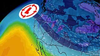
The jet stream is taking yet another southern nosedive, driving a reinforcing blast of cold air through the Rockies and High Plains, with daily record lows –and record-cold high temperatures –expected.
(MORE: )
Disturbances embedded in that plunging jet stream will help wring out snow in the Rockies, Plains and upper Midwest, possibly including some surprising places this early in the season.
The National Weather Service has posted winter storm warningsand winter weather advisories in parts ofColorado, New Mexico, Nebraska, Kansas, western Iowa and the panhandles of Texas and Oklahoma.
Here's a look at the timing and locations where accumulating snow is expected.- Into Sunday Night:Snow will taper off in northern Colorado, western and northern Nebraska and southeastern South Dakota. Any rain will change to snow in southeastern Colorado, western and northern Kansas, parts of the Oklahoma and Texas panhandles, western and northern Iowa, southern Minnesota and western and northern Wisconsin.- Monday:Some snow may linger in parts of northern New Mexicobut will have ended elsewhere. Slippery roads might persist at least early in the day in areas where snow had fallen Sunday.
(MORE: )
Most of these areas should see modest additional accumulations, particularly in southern Colorado and northern New Mexico, where somelocally heavy totals are possible in the mountains and foothills
As with most early-season events, initial snowfall might melt on pavement, but as colder air moves in and snowfall persists, slushy, snowy roads will likely develop, particularly at night.
Strong winds behind the plunging cold front could combine with snow to reduce visibility, particularly in open country. In areas of more significant accumulation, the stress from wet snow and winds might lead to some downed trees and power outages. Trees are more easily downed in early-season snowfall events due to the weight of leaves still being on trees.
At least minor snow accumulations are possible as far south as the Oklahoma and Texas panhandles. Amarillo's first accumulating snow typically happens by Nov.24but has happened as early as Sept. 29, 1984.
This would also beearly for the season's first measurable snow in Dodge City, Kansas, where it typically happens around Nov. 19. This southwestern Kansas town has a chance to pick up at least one inch of snow, which typically doesn'thappenuntil Dec. 5.
Those with travel plans in the Rockies and High Plains should check back frequently for the latest on this forecast.


 zpostcode
 Recruit
 weather
 mreligion
 Yellowpages
 sport
sport constellation
 shopping
 name
name game
game directory
 literature
 Word
Word tour
tour furnish
 Lottery
 tftnews
 lyrics
 News
News digital
 car
car dir
dir Edu
Edu Finance


