

US
°C


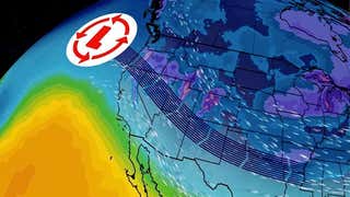
A potent storm system is spreading snow and rain from the Midwest to the South and East early this week.For some of these areas, it is the first snow of the season.Mainly rain is forecast along the Interstate 95 corridor in the Northeast and Southeast.
A storm system moving from the mid-Atlantic into New England Tuesday is bringing the first snow of the season to some cities while others are experiencing a soaking rain.
Snow is falling in parts of northern New England as heavy rain soaks the mid-Atlantic into southern and eastern New England. A few snowflakes were also reported Tuesday morning in portions of , including Houston, and northwestern Louisiana, including .
A trace of snow/sleet was officially reported Tuesday morning at Houston Intercontinental Airport, the in Houston. The old record was Nov. 23, 1979, according to the National Weather Service.
Pueblo, Colorado (3.2 inches), and Amarillo, Texas (3 inches), both saw accumulating snow on Sunday. This was the first accumulating snow of the season in Amarillo and .
Tulsa, Oklahoma (1.6inches), Springfield, Missouri (1.5 inches), and St. Louis (0.8 inches) all saw their first measurable snow of the season Monday.
The wintry side of this system has now arrived in the interior Northeast.
The National Weather Service has posted winter weather advisories and winter storm warnings for parts of Vermont, northern New Hampshire andMaine.
The low-pressure system willtrack near the Interstate 95 corridor in the mid-Atlantic and Northeast into Tuesday evening.
This system will produce snow wheremoisture from the storm interacts with cold-enough air, but where the cold air doesn't hold, rain will dominate instead. Moderate to locally heavy rainfall is expected toward the East Coast. Lighter rainfall is anticipated in the Southeast after seeing heavy rain on Monday.
Tuesday Afternoon
Snow is possible across northern New England. Lingering snow showers are possible as far south as West Virginia.
Some areas will see the snow change over to rain as milder air attempts to nudge northward.
Rain is likely closer to the East Coast from southern Maine and southern New England southward, including the big Interstate 95 cities.
Lake-effect snowbands are likely southeast of the Great LakesTuesday and intoWednesday.
How Much Additional Snow?
A few inches of additional snowfall is possible in parts of northern Maine. Lighter accumulations are expected in the Green and White mountains of Vermont and New Hampshire.
Lake-effect snowbands will produce mainly light accumulations into Tuesday evening across the Great Lakes snowbelts.
As mentioned, rain is expected along the Interstate 95 corridor from Boston to Washington D.C., but there may be flight delays due to this system at the major Northeast hubs Tuesday.


 zpostcode
 Recruit
 weather
 mreligion
 Yellowpages
 sport
sport constellation
 shopping
 name
name game
game directory
 literature
 Word
Word tour
tour furnish
 Lottery
 tftnews
 lyrics
 News
News digital
 car
car dir
dir Edu
Edu Finance


