

US
°C


Sign up for the Morning Brief email newsletterto get weekday updates from The Weather Channel and our meteorologists.
Is the gorgeous view or the glory worth the risk? When it comes to these hikes, some adventurers may decide to steer clear. Hiking trails can be dangerous for many reasons, from steep, rugged terrain to searing temperatures to frequent storms. Read on to learn about some of the most dangerous hikes in the U.S.
(MORE: The Stunning Interior Of The World's Longest Cave)
Hikers climbing down Half Dome on a sunny day at Yosemite National Park. The Mist Trail, which ascends Half-Dome, is one of the most dangerous hikes in the U.S.
(Getty Images)
Just a look at the cable route up Half Dome, and viewers can see why it’s one of the most dangerous hikes in the U.S. The 400-foot route to the top is nearly vertical, and an extreme amount of strength is needed for hikers to make it up the granite dome.
, from falls, heart attacks and other accidents such as lightning strikes, according to yosemitehikes.com. The trail to Half Dome is dangerous as well, with perilous waterfalls and precarious terrain, and has claimed more than double the lives of Half Dome alone.
The canyons of The Maze trail at Canyonlands National Park are seen in the photo above. The trail can be confusing and maze-like, as its name suggests, and temperatures can reach 110 degrees Fahrenheit.
(Cavan Images/Getty Images)
This 13.5-mile hike is definitely not for amateurs. Located in Canyonlands National Park, this trail gets its name from its maze-like terrain that weaves in and out of sandstone walls and deep canyons. Hikers following this trail should be skilled with a map and carry a GPS, as the canyons and terrain all starts to look alike.
But that’s not all that’s difficult about this hike. Temperatures can reach 110 degrees Fahrenheit. The National Park Service urges those who venture out on this trail to bring .
Camp Muir is seen at the top of the Muir snowfield above Paradise on Mount Rainier. Storms can roll in from the Pacific, creating white-out conditions and making hypothermia a threat.
(Vince Barnes/Getty Images)
This unmarked trail is dangerous for the opposite reason of the hike above. Unexpected storms can whip through the snowy terrain from the Pacific, causing disorienting whiteout conditions and threatening hypothermia for hikers. Not to mention that the 2.2-mile stretch, which is snow-covered year-round, is a physically demanding 2,900-vertical-foot climb, even for the advanced adventurer. sit on either side of the snowfield, where climbers can easily fall.
The snowfield has claimed the lives of more than 90 climbers due to falls or hypothermia. As recently as Sept. 2020, . His hiking partner was rescued and survived.
A large male Alaskan brown bear is seen taking a walk along a beach in Lake Clark, Alaska.
(Getty Images)
Grizzly bears are the real threat in this area of Lake Clark National Park. The National Park Service has reported that visitors may be able to see . It’s an area with lots of food for the bears from early spring, when they leave hibernation, until they return to hibernation in the fall.
Visitors are advised to stick to the bear viewing areas, as the consistent use of the same sites makes human use more predictable to the bears, possibly minimizing disturbance and reducing risk. Those traveling to Chinitna Bay should carry a bear canister, bear spray and refrain from eating in the area.
The Grand Canyon is seen from Bright Angel Trail on the South Rim. Temperatures can reach 110 degrees Fahrenheit, making it dangerous for hikers during midday.
(Ed Freeman/Getty Images)
With temperatures up to 110 degrees Fahrenheit, the steep terrain of this 9.5 mile hike is no easy feat. All told, hikers will traverse 4,380 feet down into the canyon, which, according to the National Park Service, .
While this is the most popular hiking trail into the canyon, it’s a challenging hike. While the hike down is fairly easy, that fact, coupled with the spectacular canyon views may distract hikers from preparing for the grueling climb back out.
Hikers are urged to begin the trail before dawn and complete it after sunset if attempting it in one day. During the summer, it may be best to break the hike into a two-day trip, allowing for plenty of rest and water breaks. The National Park Service advises visitors to . Check the weather before heading on the trail, and be sure to bring sun protection.
A teenager climbs the granite cliffs of Precipice Trail, which are fitted with iron rungs in Acadia National Park, Maine. It’s clear from this photo why this trail is dangerous.
(Jose Azel/Getty Images)
If you’re interested in hiking on a steep cliff face, head to Precipice Trail, which is one of the most dangerous hikes in Acadia National Park. Metal rungs help hikers hoist themselves up over 1,000 feet in less than a mile to the summit of Champlain Mountain. While the climb is not considered technical, it requires physical and mental strength, according to the National Park Service, and .
Hikers are also warned against descending the Precipice Trail. Instead, the North Ridge Trail from the summit is a much safer route.
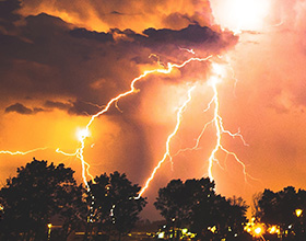
The summit of Pikes Peak viewed from the Barr Trail in Colorado. The trail is known to be a hotspot for lightning and electrical activity.
(Getty Images)
, according to the Centers for Disease Control. It’s never a good idea to be on a hike during one of the state’s infamous afternoon thunderstorms, but Pike’s Peak is especially dangerous, as it’s a hotbed for lightning and electrical activity. According to The Sierra Club, create perfect lightning storm conditions.
The Barr Trail gains 7,400 vertical feet over 13 miles, and the terrain is mostly above the treeline, through exposed meadows and boulderfields. to avoid the storms.
The Weather Company’s primary journalistic mission is to report on breaking weather news, the environment and the importance of science to our lives. This story does not necessarily represent the position of our parent company, .


 zpostcode
 Recruit
 weather
 mreligion
 Yellowpages
 sport
sport constellation
 shopping
 name
name game
game directory
 literature
 Word
Word tour
tour furnish
 Lottery
 tftnews
 lyrics
 News
News digital
 car
car dir
dir Edu
Edu Finance


