


Hundreds of flights are canceled Friday at Chicago O'Hare International Airport.Some Georgia school districts announced closures, including in the Atlanta area.NFL wild card games in Kansas City, Buffalo and Tampa all face weather worries.
Sign up for the Morning Brief email newsletterto get weekday updates from The Weather Channel and our meteorologists.
Hundreds of flights are already canceled in Chicago, schools are closing in the Atlanta area and tornadoes and high winds are possible for parts of the South - again - as the nation heads into a holiday weekend full of the potential for dangerous weather
And that's not all - a blast of brutal arctic cold air is on its way, along with another likely winter storm.
Here are the forecasts to follow:
-Winter Storm Gerri Will Bring Another Round Of Snow, Wind From The West To Midwest, Northeast
-Severe Storms Likely To Produce Wind Damage In The South
And here are our live updates as the day played out Thursday:
From digital meteorologist : Weather has been busy so far this month, and it isn't likely to let up soon.
Following Gerri's visit to the Midwest on Friday and Saturday, is expected to cruise out of the Northwest and into the Southern Plains and South by early next week with new snow and ice threats.
The new system will track further south than Gerri will, but could also bring more snow to the Northeast. The details on the new system are very uncertain for folks east of the Rockies, but we'll keep updating you as we know more.
Several Georgia school districts, including some in the Atlanta area, will close or move to online learning tomorrow due to the threat of severe weather.
Counties that have already announced closures include , , and .
From digital meteorologist : Another round of severe weather is possible tonight through tomorrow morning as Winter Storm Gerri works its way east. Isolated tornadoes, large hail, and damaging winds are all possible threats tonight, mainly in the ArkLaTex region.
Tomorrow the threat will continue across parts of the Southeast into the Carolinas, with wind gusts of up to 75 miles per hour possible.
About 600,000 homes and businesses in the U.S. were without power earlier this week as both winter weather and severe storms took hold. With more of the same on its way, now is the time to prepare.
Among the most important advice: Always have an emergency supply kit, stock up on nonperishable food and bottled water and make sure to have a plan in place for anyone in your home who relies on electricity for medical needs.
Click for a full list of tips.
From senior meteorologist Jonathan Erdman: We know the forecast in Kansas City will be frigid. It's now a question of how cold.
The last NFL game with a subzero kickoff temperature was an NFC wild-card game in Minneapolis eight years ago, a game the visiting Seattle Seahawks won over the host Minnesota Vikings 10-9.
The game was played outdoors at TCF Bank Stadium, the home of the University of Minnesota Golden Gophers, while the Vikings' new stadium - U.S. Bank Stadium - was being built. The kickoff temperature was minus 6 degrees.
There are two other potential wild-card games with weather impacts this weekend.
Lake-effect snow is possible in Buffalo where the Bills will host the Pittsburgh Steelers Sunday afternoon.
In Florida, rain and thunderstorms are possible in Tampa for Monday's night's matchup between the host Buccaneers and the Philadelphia Eagles.
Take a deeper into the forecast for these three games .
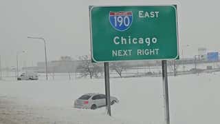
The National Weather Service has put the Chicago area under a winter storm warning starting early Friday morning and running through at least noon Saturday. "Difficult to impossible travel" is noted at the top of the list of expected impacts.
The Illinois Department of Transportation is advising people to if possible.
Nearly have already been canceled tomorrow to or from Chicago O'Hare International Airport. Major airlines including , Delta and Southwest are waiving change fees at dozens of airports into the weekend.
From senior meteorologist : Many of the coldest parts of the U.S. typically see their about this time of year.
In particular, those of you in the Northern Plains into the Midwest to the Northeast - and even the Southeast - usually feel your coldest temperatures in the last two weeks of January.
Of course this varies somewhat. Places like the Rockies and spots to the west generally see their coldest temperatures in December or early January.
No matter the location, though, the lowest temperatures of the year usually occur when bitterly cold arctic air is pulled into the U.S from Canada.
Palisades Tahoe and neighboring Alpine Meadows partially reopened today, following an avalanche that killed a skier at Palisades Tahoe yesterday.
The 66-year-old victim was the in the U.S. during the 2023-2024 winter season, according to the Colorado Avalanche Information Center.
The Placer County Sheriff’s Office identified the person killed as Kenneth Kidd, 66, listed as a resident of both nearby Truckee and Point Reyes, California. Three others were treated for injuries.
From Erdman: A blast of arctic cold is plunging through the U.S., with the potential for record lows from Washington state all the way to the Gulf Coast.
The first round of bitter cold air has already plunged through the Northern Plains and Northern Rockies. Wind chills in some spots there could dip as low as minus 60 degrees from tonight through Sunday.
But we think the most potent part of this outbreak is going to be this weekend through Wednesday morning, first from the Northwest into the Southern Plains and Midwest this weekend, then into the Southeast Tuesday into Wednesday.
Cities like Dallas and Houston could dip into the teens, and Atlanta could hover near freezing.
Click to read the full forecast for this frigid air.
A snow squall warning was or areas including Flagstaff, Arizona, where the National Weather Service said snow could fall at a rate of 1 to 2 inches per hour.
and wind gusts in excess of 35 mph were also possible.
People walk down the sidewalk as snow falls rapidly on Thursday, Jan. 11, 2024, in downtown Flagstaff, Arizona.
(AP Photo/Felicia Fonseca)
From lead meteorologist : A strong El Niño , according to the latest monthly update from NOAA’s Climate Prediction Center.
In general, this type of classic strong El Niño typically brings a wetter-than-average winter across much of the southern U.S. thanks in part to a stronger, more southern jet stream track.
The next storm we are watching for early next week, with a low pressure system tracking across the South, is fairly typical in an El Niño winter.
A tornado that caused damage in Bay County, Florida, on Tuesday was , according to the National Weather Service.
The weather service gave the tornado a preliminary rating of EF3, with exact wind speeds and track still being determined.
The tornado was part of a across the south that erupted on the warm side of Winter Storm Finn.
Severe weather damage is seen in Bay County, Florida, on Tuesday, Jan. 9, 2024.
(Bay County Sheriff's Office via Facebook)
From meteorologist : We’ve talked a lot about the back-to-back track of winter storms Finn and Gerri, and the fact that many of the same areas hit by Finn will see some of the same impacts from Gerri. But there are some differences.
For one, Gerri will have longer lasting, heavier snow for parts of the Midwest including Chicago
Also, Gerri will likely have stronger wind along with the snow than Finn had, leading to more widespread dangerously low visibility and near-blizzard conditions at times.
Here's something everyone should do, year-round: Keep in your freezer, with a coin placed on the top.
If your power goes out, the water will start to melt. When it refreezes, the coin will be partially or totally covered by water. That's a clue that your food might not be safe to eat, especially if the coin is all the way at the bottom of the cup.
A coin on top of a frozen cup of water can help you tell how long your power was out.
(Jan Childs/weather.com)
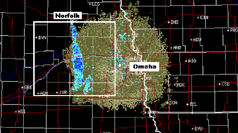
From : Winter Storm Gerri will begin to spread its snowy, windy mess into the Plains this afternoon, then into parts of the upper Midwest overnight into early Friday.
For many of these areas, this will be the fourth round of accumulating snow since late last week, after spending much of December snowless.
Friday morning's commute will be challenging in Omaha and Des Moines, and could feature an opening round of snow to slicken travel as far east as Chicagoland.
How well dogs tolerate the cold varies depending on breed. Experts say small dogs like miniature poodles and Maltese shouldn't be outside for more than 10 or 15 minutes once temperatures drop below freezing. Bigger dogs and those used to winter weather - think Bernese mountain dogs - can stay outside for as much as an hour.
Click for more on dogs and cold weather.
From: One complication in what ordinarily would be a straightforward snowstorm forecast is the ice-free, relatively warm Lake Michigan.
Water temperatures along the Chicagoland lakeshore are in the upper 30s, and farther offshore, they’re still in the low 40s. Averaged over the entire lake, it’s at since at least the mid-1990s, following the in much of the upper Midwest.
Winds blowing off the lake during the storm Friday may allow precipitation to switch to rain nearest to the lakeshore briefly, or at the very least, become a very heavy, wet snow more typical of late spring or early autumn, rather than January.
Elsewhere, heavy snow could move in as soon as the Friday morning commute, with snowfall rates intensifying into Friday night. Coupled with strong winds, roads may become increasingly impassable in northern Illinois and northwest Indiana Friday, and snow and wind may linger into early Saturday.
We strongly encourage you to change any Friday or Saturday morning travel plans into Chicagoland, whether driving or flying into O’Hare or Midway. This is a dangerous winter storm.
The caveat: While travel will certainly be challenging in the Midwest from Gerri, the most dangerous travel conditions, in which some roads could drift shut and become impassable, are most likely to happen in rural areas and possibly in some outer suburbs of cities.
It was a piece of , and now, it projects to return with Winter Storm Gerri: "heart-attack" snow. Erdman said:
That means it's very wet and heavy, as opposed to more dry, fluffy snow perhaps in other areas.
It's snow you typically expect in the upper Midwest either very early – say, late October or early November – or very late in the season, like April or May.
While this is great packing snow for making a snowman or having a snowball fight, it's a serious hazard for snow removal, particularly for the elderly or those with heart or other health issues.
Even if you only pick up, say, an inch or two of snow, you shouldn't try to shovel this heavy, cement-like snow.
Use a snowthrower to remove this, not a shovel. If you don't have a snowthrower, ask your neighbor if they can help.
Here are more tips on snow removal and safety:
-Is It Safe To Shovel Snow? Here Are Some Of The Risks
-Four Reasons Why Shoveling Snow Is So Deadly
We asked meteorologist Domenica Davis what one aspect of today's weather conditions will have her attention more than any other:
"I will be watching Texas and Oklahoma, where as the cold front comes through tonight, it will drop temperatures by 30 to 40 degrees very quickly.
And as if that's not bad enough, with winds gusting upward of 40 mph or greater, wind chills will be extremely dangerous, with the potential feels-like temperatures of minus 10 to around 10 degrees in some areas. Multiple weather hazards are possible, with flash freezing being one of the biggest concerns."
See the full forecast for Texas and Oklahoma .
If you're headed to GEHA Field at Arrowhead Stadium for Saturday night's playoff tilt between the Kansas City Chiefs and Miami Dolphins (yep, Miami), prepare for one of the coldest NFL games of all-time. Temperatures at kickoff (if not a few degrees colder), and when winds are factored in, it will feel more like minus 20.
And that's the warmest it will be all evening.
So where does that rank among the coldest NFL games ever? It has a chance to be just outside the top 5 if the current forecast holds. However, it's not likely to set a new record, which is held by the legendary 1967 "Ice Bowl" between the Dallas Cowboys and host Green Bay Packers, when it was minus 13 at kickoff.
The recent trends for both franchises are pretty clear. According to The National Desk, Miami is 0-10 in games played below 40 degrees since 2017, while the Chiefs are 9-1 in their last 10 home games in such temperatures.
Winter weather to the north, severe storms to the south. It happened earlier this week, and it's happening again.
The Ark-La-Tex will be the focus for the highest severe storm threat today and tonight, and then the risk area shifts into the Southeast tomorrow as the storms march eastward.
For a complete breakdown of the severe weather threat the next two days, .
The National Weather Service is finalizing several of its tornado damage surveys across the South, and we're learning just how strong those twisters were. Here are some of the preliminary ratings:
-: EF3
-: EF2
-: EF2
A large avalanche killed one person at the Palisades Tahoe ski resort Wednesday morning, closing the ski area and setting off a massive rescue effort for those who were buried in the snow.
According to the Placer County Sheriff’s Office, 66-year-old Kenneth Kidd was the victim, and three others sustained non-life-threatening injuries in the GS Gully area of the resort.
"This is a very sad day for my team and everyone here," Dee Byrne, president of Palisades Tahoe, told the Associated Press.
The cause of the avalanche is still under investigation. This was the first avalanche death of the season nationwide, according to the Colorado Avalanche Information Center.
To read Wednesday's live updates page, click here.
The Weather Company’s primary journalistic mission is to report on breaking weather news, the environment and the importance of science to our lives. This story does not necessarily represent the position of our parent company, .


 zpostcode
 Recruit
 weather
 mreligion
 Yellowpages
 sport
sport constellation
 shopping
 name
name game
game directory
 literature
 Word
Word tour
tour furnish
 Lottery
 tftnews
 lyrics
 News
News digital
 car
car dir
dir Edu
Edu Finance


