

Radar and satellite imagery showed industrial plants making snow in the Midwest.Warm, moist air from the plants rising into colder clouds allowed the localized snow to form.This is not the first time this phenomenon has been observed.
Industrial power plants produced snow in Indiana, Kansas and the Cleveland metro area Tuesday as a blast of cold air engulfed the Midwest.
Heat and steam fromindustries near downtown Cleveland enhanced a localized snowband, which satellite and radar imagery showed extendingsoutheastward, steered by northwesterly winds.
Dubbed the "downtown-Cleveland-enhanced"or "Cleveland-effect" snowband by the local National Weather Servive office, it was seen lowering visibility on some highways in the metro area. A few places picked up minor accumulations of snow.
Steam rising from the industrial plants sent warm, moist air into the colder air in the clouds, allowing the snow crystals to form.
This a similar process to how snow develops: a warm moisture source rises, and that rising air then cools and condenses into clouds that can generate snowflakes under the right conditions.
Parts of northeastern Indiana, including Fort Wayne, also experienced industrial power plant-induced snow Tuesday. The NWS in northern Indiana issued a series of special weather statements warning residents of "a band of industrial plant-induced heavy snow."
One of the statements noted the snowband had produced periodic heavy snow and along U.S. Highway 30between Fort Wayne and Columbia City, Indiana. An observer near Arcola, Indiana, measured 1.5 inches from this industrial power plant-induced snow.
Northwest of Topeka, Kansas, a coal power plant produced snow Tuesday. The steam released from the plant near St. Marys, Kansas, resulted in flurries and light snow across Shawnee County, Kansas, including the city of Topeka.
Industrial plants also produced snowin Minnesota and NebraskaMonday into Tuesday.
The most persistent industrial plant snow on Monday fell in eastern Nebraska, where it even accumulated in some spots.
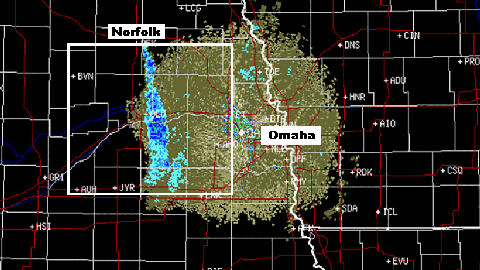
The plume of snow couldbe seen extending southward from the industrial plants located near Norfolk, Nebraska, in this radar image from Monday.
(MORE: )
Doppler radar image showing the plume of snow in various blue shadings originating from industrial plants near Norfolk, Nebraska, on Monday.
(UCAR/NOAA)
Steam exhaust from those plants continued to produce snow and freezing drizzle Tuesday morning, with winds , according to the NWS. A winter weather advisory was even issued by the NWS for Tuesday morning due to the possibility of slick travel conditions in eastern Nebraska and adjacent parts of southwestern Iowa.
An emergency manager in Madison County, Nebraska, said the plume was producing large snowflakes Monday. Up to 2inches of accumulation was reported near Leigh, Nebraska, which is about a 30-mile drive southeast of where the plants are located near Norfolk.
Minnesota also had light snow associated with an industrial plant on Monday.
Satellite imagery showed snowfall triggered by a refinery southeast of the Minneapolis-St. Paul metro. A weather observation station southeast of the Twin Cities in Stanton reported light snow for an hour Monday afternoon, according to the NWS.
Although it's not a common sight, industrial plants fuelingsnowfall does happen from time to time.
We documented another case of steam from a mine causing snow to develop in the Upper Peninsula of Michigan.


 zpostcode
 Recruit
 weather
 mreligion
 Yellowpages
 sport
sport constellation
 shopping
 name
name game
game directory
 literature
 Word
Word tour
tour furnish
 Lottery
 tftnews
 lyrics
 News
News digital
 car
car dir
dir Edu
Edu Finance


